Big Bend National Park, established in 1944, occupies the southwestern portion of Texas. Its name derives from the bends of the Rio Grande River, whose course continually shapes and redraws the border with Mexico.
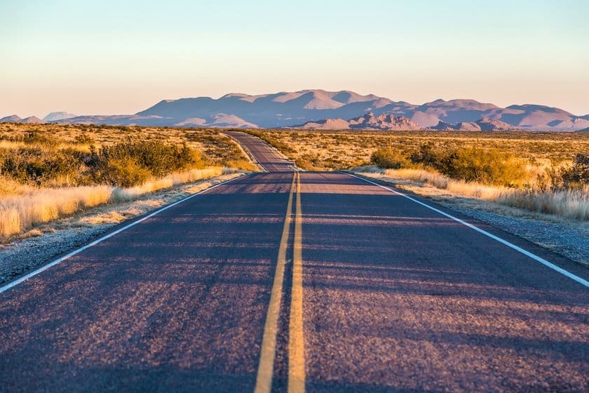
Its boundless vistas and rugged, barren land make up a quintessential landscape seen in so many Western movies. When you visit this park, which happens to be among the least visited in the United States, you will experience a fantastic feeling of freedom, mixed with bewilderment before the majestic works of Mother Nature.
If you are planning a trip to Texas and want to feel like the pioneers of the Wild West, include Big Bend National Park in your itinerary. Its sights are worth the long journey to get there!
Contents
- An Introduction to Big Bend National Park
- How to Get to Big Bend National Park
- Best Time to Visit Big Bend National Park
- How Much Time Should you Devote to the Park
- Admission, Hours, Visitor Center, and Useful Info
- Big Bend National Park: Things to Do and Points of Interest Area by Area
- Other Things to Do Near the Big Bend National Park
- Places to Stay Near Big Bend
- Places to Eat in and Around the Park
- Safety Tips
An Introduction to Big Bend National Park
Before the national park was created in 1944, this area was bandit country and the scene of border warfare. One of the most famous conflicts involved the Mexican revolutionary Pancho Villa. In 1916, Villa attacked and razed the town of Columbus (New Mexico), causing 17 casualties, and then took refuge in the Chisos Mountains and the Chihuahuan Desert. President Wilson sent a unit of soldiers commanded by General “Black Jack” Pershing. Planes were also dispatched to search for Villa, but the manhunt ended, unsuccessfully, after several months.
For years, particularly during World War I, Big Bend was protected by military garrisons, the remains of which can still be seen in some areas of the park.
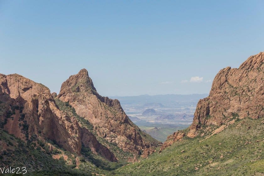
With an area of about 1235 square miles, Big Bend is divided into three areas:
- the Rio Grande River
- the Chihuahuan Desert
- the Chisos Mountains
These areas are very different from each other, which is why it is said that visiting Big Bend National Park is like visiting three parks in one.
From 1804 ft above sea level at the Rio Grande to 7874 ft in the Chisos Mountains, with a temperature range of 50-59 degrees, the landscapes also could not be more varied, with narrow canyons, wide valleys, rocky deserts, and mountains with forests.
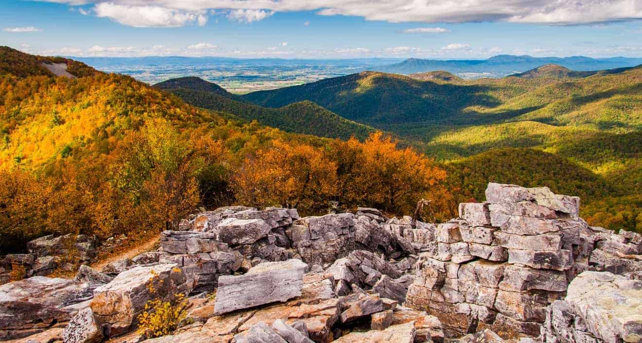
The Chisos Mountains formed about 40 million years ago as a result of violent volcanic explosions. Here visitors can cool off and admire the park’s most beautiful vistas. They occupy only 2 percent of the park’s total area, but because they are a green island in the middle of the desert they have preserved a distinctive flora that exists only here.
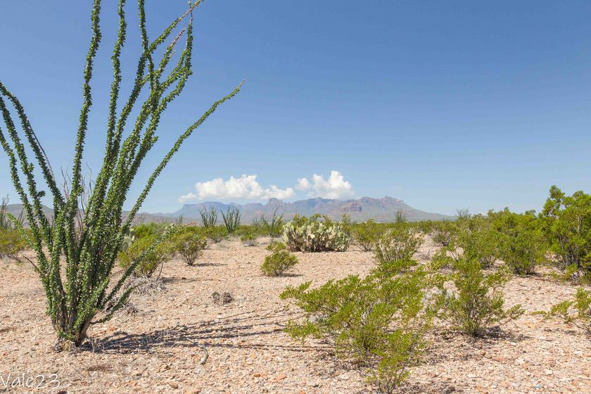
The desert has an abundant variety of local flora, such as Ocotillo, Living Rock Cactus, and Resurrection Fern. All these plants blend into the environment and have adapted to survive the extreme climate. Take advantage of the nearly 155 miles of hiking trails to discover all that the park has to offer.
How to Get to Big Bend National Park

Big Bend National Park is accessible by car and has two entrances.
- Persimmon Gap, located to the north, is for those arriving from Marathon or Fort Stockton. From Fort Stockton, take US-385 S south until you reach Marathon (59 miles). Then continue on the same road for 40 miles, and you will arrive at the park entrance turret. Travel time is 90 minutes from Fort Stockton and about 40 minutes from Marathon.
- Maverick Junction is located to the west, a short distance from the semi-fantasy town of Terlingua. Take FM 170 east to the junction with TX-118 S. Here turn right and continue for about 3 miles. Travel time is 15-20 minutes, depending on the location of your hotel.
If you are in El Paso, Carlsbad, New Mexico, or any other location northwest of the park, you will first need to reach Alpine, a town at the intersection of US-90 and TX-118.
Once here, you can either take TX 118 south, which will take you to the Maverick Junction entrance, or continue on to Marathon and the Persimmon Gap entrance, as indicated above. In the first case, the distance is 80 miles, so it will be more convenient to visit the desert and Santa Elena Canyon. Meanwhile, in the second case, the distance is 72 miles, and you will be closer to the Chisos Mountains and Rio Grande Village. Either way, you will have to calculate 1 hour and 15 minutes of driving time.
How to Include Big Bend National Park in your Itinerary
Big Bend National park is in a rather remote area of Texas, and to get there you will have to drive a long distance.
You can include it in an itinerary of the Lone Star State, or on a route that covers more territory, which may include part of New Mexico, for example, White Sands National Park, and a section of Route 66.
I recommend you visit it when you cross the Texas Hill Country, the area between Austin and San Antonio, and the Fort Davis/Midland area. If you also plan to go to New Mexico, you can visit El Paso or Carlsbad Caverns National Park on the way.
Best Time to Visit Big Bend National Park
As we have seen, Big Bend National Park is composed of distinct climatic zones, with considerable temperature differences from zone to zone. Nevertheless, the climate is desert-like throughout the park, and is arid and hot for most of the year.
- Winters are mild and dry, with rare occasions of snowfall in the Chisos Mountains.
- Summers see highs of 104° in the desert and along the Rio Grande. This season, and more generally between May and September, also corresponds to the wettest period. There are frequent afternoon thunderstorms, and there is the possibility of flooding on dirt roads and along trails.
- Spring and fall are the best seasons to visit the park, since temperatures are better and the weather is drier.
The busiest time of year is around Spring break, in mid-March resulting in housing shortages and higher prices.
How Much Time Should you Devote to the Park
Given the size of the park, you should devote at least one full day to it. If you plan to do a lot of hiking, go kayaking on the Rio Grande, or cross over to Mexico, plan for 2-3 days.
Here is a sample of what to see and do in one day at Big Bend:
- Early in the morning, explore the Rio Grande Village area, with the trail to Boquillas Canyon and the trail to Hot Springs, the thermal pools where swimming is possible.
- In the warmer hours, climb to the Chisos Mountains to enjoy the cooler weather and admire the views from the Window Trail.
- Drive along the Ross Maxwell Scenic Drive and make stops at major points of interest, such as the Homer Wilson Ranch and Mule Ears Viewpoint. If temperatures permit, you can also walk on one of the many trails that start from this road.
- Descend back to the Rio Grande and explore the Santa Elena Canyon trail.
Admission, Hours, Visitor Center, and Useful Info

Admission to Big Bend National Park is valid for 7 days from first entry and costs $30 for cars, $25 for motorcycles, and $15 for people on bicycle or without a vehicle. Because it is an NPS circuit national park, America The Beautiful parks pass is accepted. The park is open year-round.
The park has 5 Visitor Centers, two of which are open year-round, and three that are only in the winter season.
- Persimmon Gap Visitor Center, located at the access tower of the same name, is open November through April 30 from 10:00 a.m. to 4:00 p.m.
- Panther Junction Visitor Center, found about 25 miles south of Persimmon Gap, is open year-round, 8:30 a.m. to 5:00 p.m. This is the main tourist spot, where there is also a scale model of the park to better help visitors orient themselves. I also recommend stocking up on food and drinks and getting gas.
- Rio Grande Village Visitor Center, located at the south end of the park, near Boquillas Canyon, is open from November to April, from 9:00 a.m. to 4:30 p.m. This is where you will find the only other gas station in the park and a small grocery store that remains open year-round.
- Chisos Basin Visitor Center is in the Chisos Mountains area, near the lodge. It is open year-round, from 8:30 a.m. to 4:00 p.m. There is also a small museum to learn more about the flora and fauna of this area. There are no gas stations, but there is a convenience store next door, open from 9:00 a.m. to 6:00 p.m., selling groceries as well as sports and camping equipment.
- Castolon Visitor Center is at the bottom of Ross Maxwell Scenic Drive and near Santa Elena Canyon. It is open from November to April 30 from 10:00 a.m. to 4:00 p.m. The store next door, however, is open year-round.
Restrooms and picnic areas are available at the Visitor Centers, and also at these locations:
- Fossil Exhibit Discovery along Main Park Road
- Dugout Wells on Park Route 12
- trailhead for the Hot Springs in the Rio Grande Village
- trailhead for the Santa Elena Canyon
Click on this link to download maps of the park, while here you will find the brochure with up-to-date news, tips, maps, and a trail list. These documents will also be provided to you at the Visitor Center, but it is always handy to have an electronic copy.
Big Bend National Park: Things to Do and Points of Interest Area by Area
Since the park is very large and diverse, it is a good idea to break the visit down by zone. The main activities consist of driving scenic roads and hiking trails, which lead to wonderful places that are not visible from the road.
With over 155 miles of trails, you will have plenty to experience!
Rio Grande Village and Eastern Area
This area extends east of the Chisos Mountains, and most points of interest are located around Rio Grande Village on the river. From Panther Junction Visitor Center take Park Route 12 and continue for about 20 miles.
After about 6 miles you can make a short detour to Dugout Wells and the Chihuahuan Desert Nature Trail. This is a short 0.5-mile flat trail, along which some information panels explain the typical flora of the desert. It is a trail suitable for families with children, and it is possible to spot javelinas (a species of small wild boar).
The road then descends to the river in a flat landscape. Behind you, there is the silhouette of the Chisos Mountains, while in front of you, the outline of the canyon begins to emerge. Once you arrive at the Village, you can take the opportunity to refuel and do some shopping. Remember, however, that the Visitor Center is only open in winter (see hours above). There are a couple of interesting viewpoints in this area and some nice hiking trails.


Here are the scenic spots:
- Rio Grande Overlook, which has scenic views of the river and desert. To get there, stop at the rest area on the right just after the tunnel along the main road. Walk up the small hill to reach the overlook. You will probably also notice makeshift unattended stalls with small handicrafts. They are left there by Mexican vendors and are for sale. If you want to buy something, you can do so by leaving money in the piggy bank on the ground.
- Boquillas Canyon Overlook, which allows you to see the river and a section of Boquillas Canyon. Take Boquillas Canyon Road and, after about 2.5 miles, take the detour on the left to get to the overlook. Admiring the canyon from the inside and taking the trail we will see in a moment, has a whole other effect. However, if you don’t feel like walking, this overlook is a good alternative.

And these are the main hiking trails:
- Rio Grande Village Nature Trail is a 1-mile loop suitable for the whole family, with an elevation gain of 121 ft. It descends to the big loop of the Rio Grande among rocks and characteristic Ocotillo plants. If you are lucky, you may even spot some roadrunners, just like Beep-Beep from the Looney Tunes cartoon.
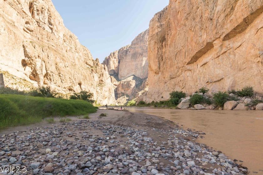
- Boquillas Canyon Trail is a linear trail that is 1.2 miles long, with an elevation gain of 229 ft. It’s not a steep climb, but it can still get tiring in hot weather. I did it at 10:00 a.m. in late September, and it was still over 86 degrees. However, once you arrive in the canyon, you will be rewarded for the effort to get there and on the way back. In fact, the trail takes you to the banks of the river that runs through very high sheer rock walls, which will make you feel very small. Mexico is on the other side of the canyon. It is incredible that the two countries are separated by only a few feet of water. If you want to go to Mexico, do not cross the river here. Read the directions further down in the article. To reach this trail, take Boquillas Canyon Road and continue for 3.7 miles to the parking lot.
- Hot Springs Trail, which leads to two hot springs pools where you can bathe. There are two ways to reach the pools. The first is by taking the longer trail at the end of Daniel’s Ranch Road, near the Village. In this case, the trail is 5.6 miles round trip, with an elevation gain of 918 ft and exceptional views of the river. The second way will allow you to shorten the walking distance considerably. From Rio Grande Village get back on the main road, and drive about 3.7 miles west, at which point you will see Hot Springs Road,a dirt road, on the left. Continue to the end (1.5 miles) and you will arrive at the parking lot and the other trailhead. From here, the pools are about half a mile away. In case of flooding, the pools may be inaccessible, so inquire at the Visitor Center before you go.
Chisos Mountains and the Central Area
This is the area of the park at the highest altitude in the park, characterized by green forested peaks. The main attraction is the Window, a space between the mountains that offers a splendid view of the desert.
From the Panther Junction Visitor Center, take Gano Springs Road west, and turn left onto Basin Junction Road, also known as Chisos Basin Road. This scenic road climbs in serpentine curves for more than 1970 ft and will take you from the desert to the mountains with a distinct change of scenery. Bushes give way to tall trees, and the vegetation becomes gradually richer and denser. Before you know it, you are in the middle of the forest. Take time to stop at the many rest stops to admire the view and take pictures of the imposing mountain massif.


Once you arrive at your destination, there will be several hiking trails to choose from. These are the most popular ones:
- Window View Trail is a simple, paved, level, 0.3-mile loop that leads to an overlook with a splendid view of the natural window. It begins at the Visitor Center and is accessible to people with mobility challenges.
- Window Trail is the most traveled trail in the area because of its scenic beauty. It is 5.2 miles long, with an elevation gain of 951 ft. It has two entrances, one at the Visitor Center (next to the Window View Trail), and the other at the campground. In both cases, the trail descends into the Chisos Basin through vegetation to the famous Window, and then to the point where the two sides join. Toward the end, you will come to a fork. Keep left to stay on the trail. The last section is a bit rocky. The return will then be quite challenging because it is all uphill.
- Chisos Basin Loop is a 2.5-mile loop with an elevation gain of 459 ft. You will start behind the convenience store and follow the signs. In fact, this trail shares several sections with other trails, but there are signs at each junction. Since this is a loop, you can go either left or right at the first fork. The trail climbs through some brush with some panoramic views of the Window and Emory Peak, which at 2385 feet is the tallest mountain in Texas.
As you descend from the mountains along the scenic road, make some stops to admire more views of the valley. Once you reach the main road, turn left. From here you will cross into the western part of the park. Shortly after turning, you will notice a white dirt road on the right. This is the Grapevine Spring Road, a 15-mile road (round trip). It is in good condition and suitable for most vehicles.
Just before the end, on the right, you can take the Balanced Rock Trail, 1.86 miles in all and with 75 ft of elevation gain. The trail winds through unusual sandstone formations that may remind you of scenery in Utah, and leads to a large “hanging” boulder, precariously resting on two other pinnacles.
The Chihuahuan Desert, Ross Maxwell Scenic Drive, and the western area
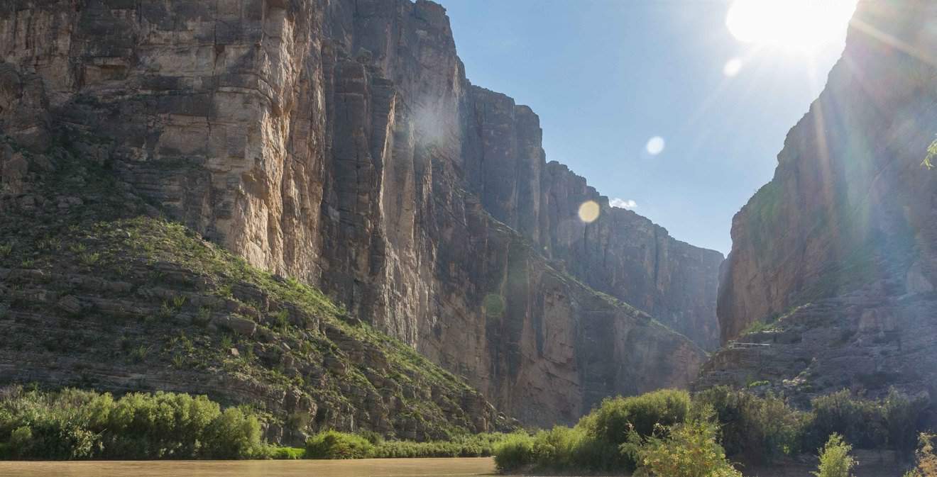
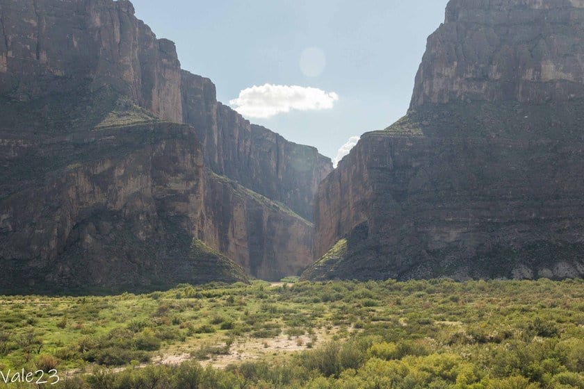
Whether you are coming from Panther Junction Visitor Center or the Chisos Mountains, head west on Gano Springs Road. After about 20 miles, turn left onto Ross Maxwell Scenic Drive, the most beautiful scenic road in the park. Fifty miles of pure beauty await you, through the Chihuahuan Desert and down to the second portion of the canyon, Santa Elena Canyon, carved by the Rio Grande, under the ubiquitous gaze of the mountain range.


Along the way, there are several scenic spots, remnants of early 1900s ranches, and hiking trails. Here are the main points of interest from north to south:
- Sam Nail Ranch is an adobe-style home nestled in a green lush oasis of willows, walnuts, and soapworts, with water pumped from the still-functioning windmill.
- Burro Mesa Pour-off Trail is a 1.6-mile trail with 147 ft of elevation gain. The trail runs along a dry creek bed, entering a multicolored canyon. At the end of the trail, there is a steep cliff face named Burro Mesa.
- Homer Wilson Ranch is a 1929 farm where goats and sheep were raised. The building is listed on the National Register of Historic Places.
- Sotol Vista Overlook is an overlook with a 360-degree view from the desert to the Chisos Mountains. On a clear day, you will even see the Santa Elena Canyon.
- Chimneys Trail is a 4.6-mile hiking trail with 364 ft of elevation gain. The trail has no shade, and traverses the desert with sweeping views of the entire area, up to the two rock formations called chimneys, hence the name of the trail.
- Mule Ears Spring Trail is one of the park’s most distinctive trails. 3.9 miles long and with 361 ft of elevation gain, it leads to a small spring and bizarre rocks that resemble donkey ears. If you prefer not to hike the trail, you can still see these rock formations from the parking lot.
- Tuff Canyon Overlook sits above the canyon of the same name and the Chisos Mountains. You can also hike the 1-mile trail that descends into the narrow meanders of the canyon and arrives at the base of a high cliff face.
At the end of the Ross Maxwell Scenic Drive, you will arrive at the Castolon Historic District. Here you will also find the Visitor Center (open only in winter) and the convenience store. This area was also home to Camp Santa Helena, and the settlement of La Harmonia Ranch. You can still see some of its buildings since the ranch remained active until the 1960s.
Continue west, skirting the massive cordillera of Santa Elena Canyon, and stop at the viewpoint. From here you can see the solid rock wall, which appears to be cut in half by the patient erosion work of the Rio Grande. Further on, you will reach the mouth of the trail. The trail, 1.5 miles long and with an elevation gain of 610 ft, goes deep into the vertiginous canyon walls, following the course of the river with truly impressive panoramic views.


At this point, to leave the park you have two alternatives. You can turn back along the Ross Maxwell Scenic Drive and then rejoin the main road, or you can take the Old Maverick Road, a 15-mile dirt road that connects back to Terlingua through the desert. To travel this road, which is impassable in rainy weather anyway, it would be wise to drive a 4×4 vehicle, since it is somewhat bumpy. Calculate about an hour as travel time because the speed limits are very low.
Other Things to Do Near the Big Bend National Park
Here is a list of other activities you can do in and around Big Bend National Park.
Kayaking in the Rio Grande
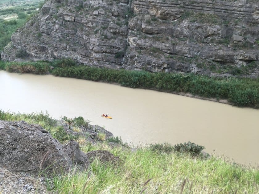
Viewing the canyon from the river is a unique experience. Here you can also spot beavers, herons, kingfishers, and turtles. You will also be able to witness the quiet lives of Mexican fishermen and farmers, going about their daily activities. You can use your own kayak, if you have it, or book a tour with some local companies, such as Angell Expeditions, Big Bend River Tours, and Big Bend Boating and Hiking Company.
In any case, always inquire at the Visitor Center before venturing out, and make sure to notify the staff about the number of people in your group, where you are going, and for how long. A complete list of local businesses for rentals, guided trips, and other services can be found here. If you are looking for a guided tour, here is one with great reviews.
Cross the Mexican border (Boquillas del Carmen)

Having come this far, it may be very tempting to cross the Mexican border and visit a tiny village called Boquillas del Carmen.
To do so, first, go to the Boquillas Crossing Port of Entry armed with your passport. The hours of the office located near Rio Grande Village are as follows:
- From 1/5 to 1/11 Friday through Monday, 9 a.m. to 4 p.m.
- 2/11 to 3/30/4 Wednesday through Sunday, 9 a.m. to 4 p.m.
After you register, a small boat will take you to the Mexican side of the Rio Grande for $3 round trip. Boquillas del Carmen is about half a mile away, and to get there you can either walk or ride a donkey.
Once you have arrived, report to the immigration office to pay the $3 fee to enter Boquillas del Carmen. At this point, you will be free to walk around the village, shop, or do some hiking with local guides. You will, however, have to return to the United States within the day. If you want to spend one or more nights in Mexico, you will need to apply for a temporary visa. Before you leave, check the updated information on the official website.
Drive along River Road
This road, whose official name is FM-170 connects the towns of Lajitas and Presidio on the way to El Paso. It runs along the Rio Grande for 50 miles, with scenic views of the river, and access to several trails and old settlements.
The following are the main attractions:
- Closed Canyon Trail is a 1.86-mile trail with 393 ft of elevation gain. It follows a creek bed through a narrow slot canyon, and up to the river. If there is rain, recent or ongoing, it is best to avoid venturing far on the trail because of the risk of flash floods.
- Hoodoos and Balanced Rocks Trail, is a 1.8-mile loop along the river that allows you to see hoodoos, similar to the sandstone “mushrooms” typical of Utah.
- Fort Leaton State Historic Site, Presidio. This fortification was originally a private residence, purchased in 1848 by bounty hunter Benjamin Leaton. Used at one time as the county administrative headquarters, it has passed through several owners, almost always violently. The buildings can be visited daily from 8:30 a.m. to 4:30 p.m. Admission costs $5 for adults and it is free for children under 12.
Places to Stay Near Big Bend
In a park this large and this remote, the best option would be to stay overnight in the park itself, or in the nearby Terlingua, which is little more than a ghost town, but logistically convenient.
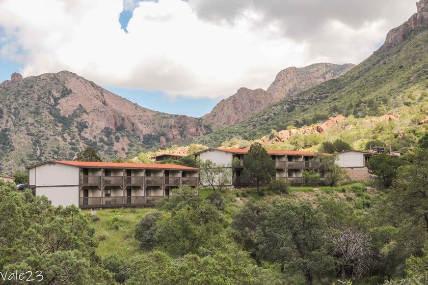
Within Big Bend, there are several campgrounds and the Chisos Mountain Lodge, the only hotel, located in the central area. Sleeping in the park is also a unique opportunity to view one of the most beautiful starry skies of your lifetime. In fact, Big Bend is part of the International Dark Sky Association, an association that recognizes the places in the world with the least light pollution.
In Terlingua, on the other hand, you can stay at the rustic Terlingua Ranch Lodge, or at the Lajitas Golf Resort, which offers more services.
Alternatively, you can push on to Alpine (93 miles), a clean and orderly college town with a charming downtown dotted with murals, as well as stores, supermarkets, and restaurants. Several motels can be found here. Two good options are the Quality Inn and the Maverick Inn.
Places to Eat in and Around the Park

If you stay in the park, you will have as your only option the restaurant at Chisos Mountain Lodge, which serves American and Tex-Mex dishes. They also serve a hearty breakfast here (not included in the room rate), and there is the option of ordering a picnic basket with a sandwich, water, snacks, and a piece of fruit. The rooms are equipped with microwaves, so if you prefer to buy something to heat up and consume in your room, you can do so.
In Terlingua, I recommend the Starlight Theater, which serves burgers and Tex-Mex dishes, but more importantly, offers live music events from Thursday through Monday.
If you are staying in Alpine, try the Cow Dog, a food truck open for lunch that serves delicious hot dogs with a wide selection of toppings. Also in Alpine, you can enjoy a variety of meat and seafood dishes at Reata Restaurant, a more expensive and sophisticated option, while at La Casita you can eat Mexican specialties such as tacos, enchiladas, and fajitas.
Safety Tips
When planning a visit to Big Bend National Park, prepare yourself for the weather conditions and wildlife you may encounter.
Trekking and Clothing
First, go to the Visitor Center and ask for up-to-date information about the weather and road conditions, especially dirt roads and hiking trails. It is also a good idea to check the park’s official website, where all the most recent information is posted.
Pets are not allowed on hiking trails.
When you set out on a trail, bring plenty of water or energy drinks, and some snacks such as cereal bars, which help restore minerals. The park brochure recommends 1 gallon (about 4 liters) of water per day. This amount may seem excessive, but it is necessary in order to stay hydrated in the arid desert climate.
Bring sunscreen with a high SPF and wear a hat. Also, bearing in mind the temperature change between areas of the park, always carry a sweatshirt or fleece. And don’t forget a change of clothes, because you will sweat a lot. I didn’t bring anything, and after the first trek I was completely soaked, and I couldn’t even turn on the air conditioning in the car, lest I got sick.
Wildlife
The park is populated by many animals, including brown bears, cougars, coyotes, javelinas, and rattlesnakes. The animals generally do not cause danger unless they are threatened first. That’s why it’s important to keep your distance, don’t feed them, don’t leave food unattended, and use the special bear- and cougar-proof waste baskets. For more information read the park’s safety tips.
Guide
There are some wonderful dirt roads at Big Bend National Park, just waiting to be explored. They are generally well-maintained, but it would be best to have a vehicle with high ground clearance, or a 4×4. Pay attention to rocks and potholes and proceed with caution. Remember that rental company insurance does not cover any damage caused by driving on dirt roads (We have explored this topic in more detail here).
Unless it can’t be avoided, do not drive in the dark. Artificial lighting is virtually nonexistent, so visibility is highly reduced. In addition, wild animals tend to come out at night, when it is cooler and often cross the roads.
Personal safety
Finally, remember that you are near the border, and the Border Patrol regularly patrols the area. Keep your passport handy at all times.