In Yosemite National Park there are many waterfalls. Some are small and not too high. Others are majestic and imposing. One of the most popular waterfalls is the famous Yosemite Falls which, as we have explained many times, it would be better to visit in the period from October to May (if you are lucky even until June), because during the summer the water flow tends to diminish considerably, and only the late summer downpours can restore them.
Other waterfalls in Yosemite, on the other hand, while reaching their peak water flow in May, flow powerfully all year round, such as Bridalveil Falls (another Yosemite highlight), Vernal Fall, Nevada Fall, Illilouette Fall, Wapama Falls, and Chilnualna Falls. However, if you want to visit Yosemite Falls in the summer, you may not always find them dry or reduced to an almost invisible stream. In fact, more than one visitor has reported to us that they found them with a fair amount of water…
Contents
Hiking Yosemite Falls, the Highest Waterfall in North America
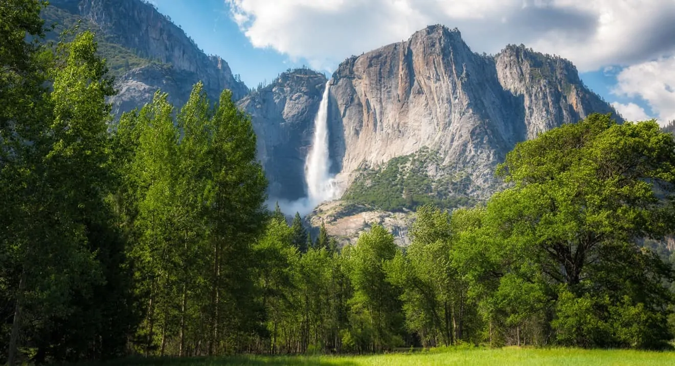
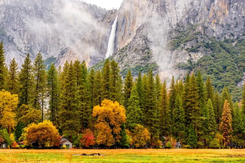 After the summer, when the waterfalls are often reduced to empty ravines, but then comes the spring thaw that prodigiously transforms the shallows of Yosemite Falls into rushing vertical streams. This is when these falls are transfigured into something magnificent, into a waterfall of 2,425 feet of elevation, no doubt the highest in all of North America. You’ll find the waterfalls in their full splendor precisely during May when water flow is at its highest and strongest.
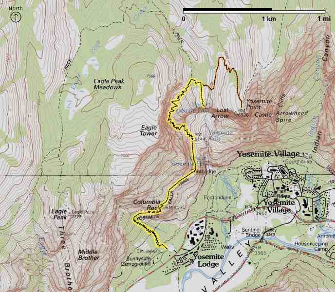
The soaring Yosemite Falls are divided into three falls: Upper Yosemite Falls, Middle Cascades, and Lower Yosemite Falls. But how do you get as close as possible to admire how powerful it is? You will be able to follow two or three very different trails and, as a result, the viewpoints you will reach will offer various views and all of them, in their own way, are fascinating. Here are detailed descriptions of all the trails (for hikes to the other waterfalls, please have a look at our post about Yosemite Valley).
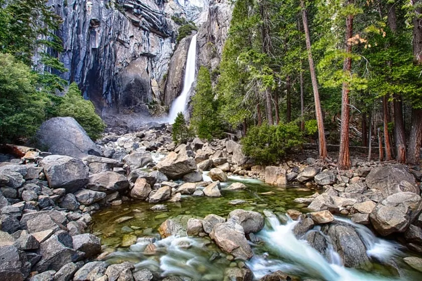
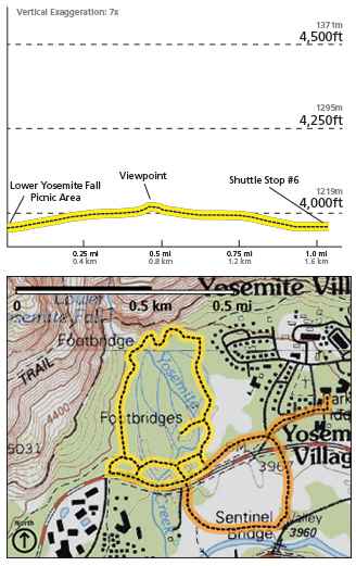
Lower Yosemite Falls
- Distance: 1 mile
- Elevation: 50 ft
- Difficulty: Easy
- Time: 30 minutes
The Lower Yosemite Falls are the lowest level of the waterfall, for a height of 320 feet. The only way to reach the base is to follow this short, easy loop. The viewpoint is so close that, in spring, the wind lifts the splashes and blows them up to your face.
No special athletic ability is required to tackle this mostly flat walk through the woods on a trail where is it possible to use strollers. If you are lucky you may even meet some friendly specimens of Yosemite’s wildlife.
At some point, you will arrive at an open space in front of the waterfalls. You will feel the splash of the Lower Yosemite Fall, but if you look up, you will feel a rush of excitement as you see the top of the waterfall. You’ll also have the chance to see some unbelievable views of Yosemite Creek.
It is very easy to reach the trailhead of this trail. Start walking from the Valley Visitor Center and follow the bike path for just under a mile, until you find the entrance to the well-marked path, near shuttle stop #6. From there, as mentioned above, you’ll walk another mile in total. Some choose to reach the beginning of the path by car, but no parking is provided. Don’t park there, because you would have to leave it on the side of the road, which is risky.
Upper Yosemite Falls
Columbia Rock
- Distance: 2 miles
- Elevation: 1,000 ft
- Difficulty: Moderate
- Time: 2-3 hours
Top of Yosemite Falls
- Distance: 7.2 miles
- Elevation: 2,700 ft
- Difficulty: Difficult
- Time: 6-8 hours
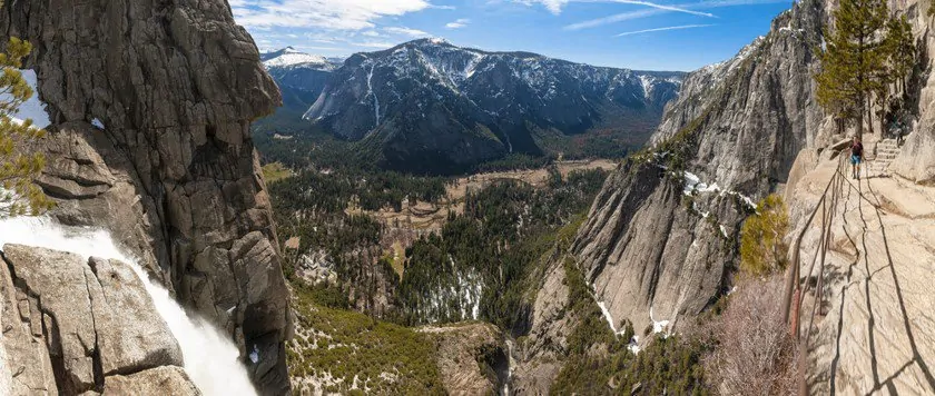
 If you don’t want to just see the waterfall from below, there is also a way to reach the top and enjoy the breathtaking view from the top of its 2424 ft. As you can imagine, this hike is much more challenging, but the final prize at the finish line is something else entirely.
The trail to the top is one of the oldest in the entire park and also one of the most popular among hikers wishing to visit Yosemite. It starts near Camp 4, near Yosemite Lodge. You will ascend through an oak forest, and already along the way you will enjoy some spectacular views of the valley. But the best part will come after ascending 1000 feet when you reach Columbia Rock, an outlook that will offer you an open and wide panorama of Half Dome, Sentinel Rock, and the whole valley. From here, continue another half mile and you’ll see the sought after Upper Yosemite Falls.
But those who are more daring can go further. From here on, the rocky trail becomes even harder and steeper and reaches the top of the waterfall. You’ll realize how small Yosemite Creek, the river that supplies water to the waterfall, is compared to the rushing waters that crash almost 2624 ft below. From here the view is definitely unforgettable, but remember that it is a very challenging trail, with an elevation that could be difficult for beginners.
Once you reach the top of Upper Yosemite Falls, you may also decide to go on other trails, either to the east, towards Yosemite Point (1.6 miles more, moderate trail) or to the west, towards Eagle Peak (5.8 miles more, difficult trail).
Yosemite Falls Trails: General Rules
Especially on these last two trails, you should follow some general rules:
- Stay on the marked trails, especially near the top of the waterfalls;
- If you have any questions about the conditions of the trails, contact the rangers at the Valley Visitor Center;
- Especially if you are climbing to the top, use clothing and shoes suitable for hiking in the mountains;
- Bring water and food, since you won’t find any on the way;
- Always take your garbage down to the valley.