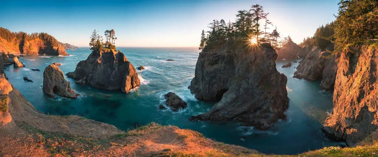
It’s well-known that the Oregon coast is a true natural gem, which is why it has earned a spot on the list of the “7 Wonders of Oregon.” Today, we’re talking about a particularly picturesque stretch, the Samuel H. Boardman State Scenic Corridor, located just over 12 miles north of the California border.
Contents
What is the Samuel H. Boardman State Scenic Corridor?

Like many other lesser-known treasures of the state of Oregon, this astonishing state park also deserves to be visited, enjoyed, and admired for the sheer volume of beauty it radiates. Breathtaking views of sea stacks rising from the ocean, rugged cliffs, ancient trees, and secluded beaches await you. Through the numerous scenic trails that lead to the most stunning vistas along the coastline, you can experience the sensation of embracing the vastness and power of the Pacific Ocean.
How to Get There

Situated in Oregon between Brookings and Gold Beach, the Samuel H. Boardman State Scenic Corridor is encountered shortly after crossing the border that separates Oregon from California to the south. There are no official entrances or visitor centers; the memorial plaque at House Rock View is the only sign that commemorates Samuel H. Boardman, the first superintendent of Oregon’s parks and the visionary behind this coastal park.
This panoramic “corridor,” nestled between the ocean and the forest, stretches for about 12 miles along the coastal Highway 101. Usually, this stretch of highway is traversed by those who are swiftly traveling the entire coastline or significant portions of it. It may happen that, due to the many miles covered or yet to be covered, the encounter with these hidden natural gems occurs by chance and then develops hastily. The advice is, therefore, to plan a thorough and leisurely visit to fully appreciate the precious points of interest encountered along this marvelous coastal passage.
Trails and Viewpoints
To explore this coastal stretch, you can choose to move from one viewpoint to another by vehicle, or walk along the interconnected pedestrian path, connected by the many trails that cross it. Below are the main attractions that follow one another, from south to north, along the oceanic coast. To help you navigate, I’ve marked panoramic viewpoints and parking areas along the route on the map above. Simply input them into your navigation system to reach them.
Cape Ferrelo e House Rock

The well-marked entrance to the Cape Ferrelo Viewpoint parking area is just over 2 miles north of Brookings, shortly after the tranquil Lone Ranch Beach. From this convenient vantage point, you can observe the picturesque slope covered with shrubs, grass, and flowers, descending to a cove adorned with rocks of various shapes and sizes resting on the shore or emerging from the sea.
On the left edge of the parking area, there’s a loop trail of about a mile and a half with a slight incline, leading to Cape Ferrelo. From the top of the promontory, you can savor the sea breeze carried by the wind and enjoy a splendid view southward to Brookings. For those looking for a longer hike, on the right side of the same parking area, a 2.3-mile linear trail with an elevation gain of 158 meters leads to the House Rock Viewpoint. To reach it more easily, you can return to your car and drive there directly. As mentioned earlier, you’ll find the commemorative memorial dedicated to the creator of the state park at this point.
Whaleshead Beach

To access this iconic beach with its fine gray sand, you can choose to take the steep and short trail that descends directly from the Whaleshead Viewpoint, or more conveniently, start from the parking area located near the beach itself. It’s worth taking a stroll on the approximately 1.2-mile-long beach. The beach is famous for its picturesque sea stacks, including the Whaleshead Rock, the large rock resembling a “whale’s head,” which gives the beach its name.
Indian Sands e China Beach

From the Indian Sands Trailhead parking lot, the approximately 1.8-mile loop trail starts with an elevation gain of 282 feet and has a moderate difficulty level. The trail offers the opportunity to admire beautiful coves, breathtaking coastal views, and patches of fine sand formed by the gradual erosion of the sandstone cliffs.
Resume your car journey, and after crossing the Thomas Creek Bridge, park at the North Island Trail Viewpoint. From there, you can take a steep trail down to reach China Beach, a stunning beach characterized by numerous sharp sea stacks emerging from the sea just a few meters from the shore. Keep in mind that the trail is about 1.2 miles round trip with an elevation gain of approximately 492 feet.
Natural Bridges

To reach this amazing natural attraction, you need to park at an unpaved pullout along Highway 101. The sign “Natural Bridge Viewpoint” is well-marked in both directions. There are two possible loop trails to follow, both of them short. The first is just under 0.6 miles round trip with an elevation gain of 154 feet, while the second is about the same length but with a lower elevation gain of 59 feet. These trails will allow you to admire one of the most sensational viewpoints in the park. Large arching sea stacks appear to form natural rock bridges, and at their ends, some fir trees stoically anchor themselves.
Secret Beach

At about 2,800 feet north of Natural Bridges, you’ll find the trailhead that leads to Secret Beach. At this point, the pullout area (Secret Beach Trailhead) is even more basic and the attraction is not signposted. The trail winds downhill through dense forest, covering a distance of about 1 mile round trip with an elevation gain of about 375 feet. In this section as well, you can admire stunning sea stacks of various sizes, and observing them from sea level provides a unique perspective. The two coves that form the beach are both very beautiful. However, access to the shoreline is subject to tidal conditions.
Arch Rock

The view of Arch Rock and the two bays nestled on both sides of Windy Point is something magical. The arch-shaped rock emerges from the ocean off the promontory, and as the sun is about to set, the low rays are filtered through the central opening in the rock, creating evocative light effects with the ripples of the waves. The close-up view of the large sea stack topped by some Sitka spruce trees, positioned almost in the center of the northernmost bay, is extremely picturesque.
There’s an easy half-mile loop trail with almost no elevation gain that connects all the best vantage points you can admire from this promontory. This trail is also popular among birdwatchers: many bird species find protection and shelter both among the rocky outcroppings and among the branches of the conifers that populate the lush area. To reach it, enter “Arch Rock State Park” in your navigator.
Places to Eat
For a picnic lunch or dinner in this beautiful Oregon park, you can take advantage of the many picnic tables available in the rest areas. If you’re looking for a hot meal, the nearest restaurants can be found in the towns of Brookings or Gold Beach.
Where to Stay
The only lodging options you can rely on to spend the night along the “corridor” are located near Whaleshead Beach. The Whaleshead Beach Resort, rents elegant bungalows with finely finished rooms and superb views of the Pacific Ocean. In Brookings, the Beachfront Inn can offer its guests a heated outdoor pool with a sun deck and a hot tub, as well as rooms with private terraces overlooking the sea. Also in Brookings, there are some more budget-friendly options: the Lucky 7 Casino & Hotel offers spacious and well-maintained rooms, an indoor pool, a fitness area, and a diner-style restaurant.