If you’re planning a trip to the American Southwest, you’ll likely include a stop at least one of Utah’s Mighty Five, the five magnificent national parks in Utah.
Among these, there’s the spectacular Zion National Park, renowned for its breathtaking hiking trails amidst majestic mountains. However, not everyone is familiar with its more remote part, the Kolob Canyons, accessed through a different entrance.
Let’s explore why it’s worth visiting and how to discover it both by car and on foot.
Contents
What is Kolob Canyons?

The Kolob Canyons are a series of narrow and deep gorges with towering red sandstone walls, situated in a remote area of Zion National Park. This region has been part of the national park since 1956, but it was designated as a National Monument as early as 1937.
Even today, it remains a much less visited area compared to the larger and more famous section of Zion, partly due to fewer amenities. However, there are compelling reasons to venture there, especially if you’re seeking captivating hikes away from the more touristy trails. There’s only one paved road that penetrates this section of the park, and to reach the most beautiful spots, comfortable shoes and a hiking excursion are necessary.
Below, I’ll delve into this section of the park, but if you’re interested in all of Zion, I recommend reading our comprehensive guide to the National Park.
Kolob Arch

The most significant natural attraction in the area, though not among the easiest to reach, is the Kolob Arch. With a span of 285 feet, this colossal stone arch ranks second in the United States, surpassed only by the Landscape Arch in Arches National Park. Considering that the Landscape Arch has weathered to the point of impending collapse, the Kolob Arch is poised to claim the national record in the future. On a global scale, there are four longer stone arches, all located in China.
Unlike other natural arches, the Kolob Arch can only be seen from a distance. Positioned at a higher elevation, pressed against a rock wall, it can only be observed from below by reaching the forest floor via a lengthy trail, which I’ll discuss shortly.
Kolob Canyons Map and Directions
The Kolob Canyons are located in the northwestern extremity of Zion National Park, in an area that, as mentioned, is effectively separated from the rest of the park. The only way to reach them from the main area of the park without exiting is to embark on an extensive hiking route.
In essence, however, it can be said that you need to get back into your car and head west and then, by taking the I-15 highway, head north. At exit 40, you’ll find the visitor center immediately, precisely here. It’s worth noting that the two visitor centers, the main one in Zion and the one in Kolob, are over 37 miles apart from each other.
Therefore, you should allow at least 45 minutes by car to travel between the two visitor centers. That’s why it makes sense to include Kolob Canyons as a stop between Zion and the preceding or following destination during your journey.
Tickets and Hours of Operation
The Kolob Canyons (both the scenic drive and trails) are open year-round. However, the Kolob Canyons Visitor Center has operating hours from 8 AM to 5 PM.
The entrance fees for the park are the same as those for the main part of Zion National Park. Therefore, the fees are $35 per vehicle or $30 per motorcycle. If you arrive at the park without a vehicle, such as by bicycle or on foot (perhaps through a hike originating from another area), individuals over 16 years old pay $20 per person at the Visitor Center.
If you have already paid for entry to Zion, you do not need to purchase an additional ticket to visit the Kolob Canyons area, and vice versa.
As it is a National Park, the America the Beautiful Pass is valid. My advice is to determine how many and which parks you plan to visit during your trip, adding up the individual entrance fees. Typically, it is worth purchasing the pass if you plan to visit at least three parks, but it also depends on which parks, as entrance fees vary.
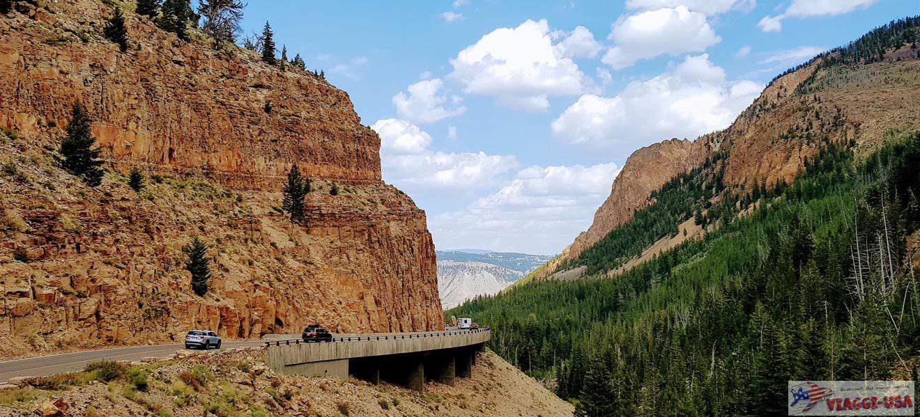
Kolob Canyon Scenic Drive

Also known as the Kolob Canyon Scenic Drive, the East Kolob Canyon Road is the only paved road that ventures into this secluded area of Zion National Park. It starts from the Kolob Canyons Visitor Center and leads to the Kolob Viewpoint, the most famous scenic point in the area. It’s worth taking your time on this drive, as it is captivating in its entirety, not just at the destination. On the other hand, being only 5.2 miles long, it can be covered in less than a quarter of an hour by car. This means that, round trip, you only need about half an hour, plus the time you want to spend at the viewpoint to admire the beautiful scenery.
The road is accessible year-round, but during winter, there may be days or weeks when the road is closed due to snow or inclement weather. Therefore, if you plan to visit in winter, it’s advisable to check the official website beforehand.
Other Scenic Drives
Indeed, there are other beautiful scenic drives to consider if you have enough time and want to explore less-traveled routes. Specifically, there are two roads branching off from UT-9, the road providing access to Zion National Park. These are the Kolob Terrace Road and the Smith Mesa Road, both leading to viewpoints overlooking the southern side of Kolob Canyons. You can find more detailed information about them here.
Kolob Canyons Trails

As I mentioned, the scenic drive allows you to reach an observation point, but to explore the park more thoroughly, you need to take one or more hiking trails. Below, I suggest the five main day-hike itineraries. Additionally, more experienced hikers might embark on longer treks, even walking between this area and Springdale, but these are truly lengthy and challenging routes.
- Timber Creek Overlook Trail: This trail is just 0.6 miles long (1.1 miles round trip) and nearly flat, making it the easiest trail. It starts from the Kolob Viewpoint parking lot, at the end of the scenic drive, and leads to a beautiful observation point. The round trip takes just over half an hour, but I recommend planning for a total of one hour to have time to enjoy the scenery and take some photos (starting point).
- South Fork Taylor Creek Trail: This 2.7 miles round trip trail, with an elevation gain of 1060 feet, follows the southern branch of Taylor Creek. If you want to venture into one of the narrow canyons of the park, this hike is recommended (starting point).
- North Fork Taylor Creek Trail and Middle Fork Taylor Creek Trail: These two trails have the same starting point and both run along Taylor Creek. At the Larson Cabin junction, you can continue along the North Fork or the Middle Fork. Considering round trip, the first is 4.7 miles with a 725 feet elevation gain, and the second is 5 miles with a 620 feet elevation gain, so they are very similar in terms of difficulty and duration. Similar to the South Fork route mentioned earlier, both of these trails lead into two narrow canyons parallel to the previous one. In my personal opinion, the Middle Fork is the most beautiful (starting point).
- Verkin Creek Trail (Kolob Arch): The Verkin Creek Trail is the main trail leading to the famous Kolob Arch. The round trip is 14 miles with a 1670-feet elevation gain, making it a challenging hike that requires a full day and is not suitable for inexperienced hikers. Near the point where the Kolob Arch Trail (just 2750 feet long) branches off from the Verkin Creek Trail, there is a campsite. So, those with a tent and sleeping bag can stay overnight and return the next day (starting point).
Best Places to Stay near Kolob Canyons
In the immediate vicinity of this area of the national park, there are no hotels. The only accommodation options, apart from camping, are some vacation homes like this one, this one, or this one. Alternatively, a short distance away, you’ll find a truly unique lodging option: an igloo tent from which you can admire an incredible panorama while being completely immersed in nature.
Searching for a hotel in Cedar Cit is the best choice if you need to travel north from the park (or vice versa if you need a stopping point before the visit, coming from the north). However, if you are heading south or arriving from that direction, I suggest looking for a hotel in St. George.