The natural beauties of the Southwest are countless, so much so that a lifetime wouldn’t be enough to explore the vast territory of California, Nevada, Arizona, Utah and New Mexico. There are easily accessible places and remote regions, famous parks, and hidden gems to discover. Above all, there’s a place that is the secret (and often forbidden) dream of every American and non-American hiker: The Wave in Arizona.
Whether you are frequent travelers in the U.S. territory or experiencing it for the first time, I bet that at least one photo of The Wave has undoubtedly caught your eye, leaving you amazed and intrigued. Well, know that reaching this location won’t be immediate (the hike is not straightforward), but it’s not as difficult as one might think, considering it is along one of the most common routes in the West. It’s not far from Highway 89, connecting Kanab and Page, towns on the border between Utah and Arizona that serve as convenient bases for visiting essential stops such as Zion and Bryce in Utah and Antelope in Arizona.
So, why is The Wave considered a forbidden dream? And why can only a relatively small number of people claim to have set foot in this mysterious desert area? Keep reading the article to find out, and perhaps to try to be one of them!
Contents
The Wave: what is it and where is it located?

The Wave is located at the base of the North Coyote Buttes, within the area known as Paria Canyon-Vermilion Cliffs, in the Colorado Plateau. The area is managed by the Bureau of Land Management (BLM) at the Kanab office of the Grand Staircase–Escalante National Monument.
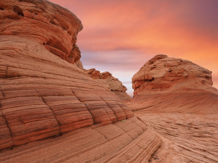
The Wave is a Jurassic-era Navajo sandstone formation that exhibits a unique interplay of U-shaped grooves formed by erosion. The two main grooves have dimensions of 62 feet by 118 feet and 6.5 feet by 52.5 feet. The erosion of these rocks was initially caused by the action of rainwater currents; however, after the reduction of the watershed, the grooves were only carved by the wind, as evident from the orientation of the sandstone steps that characterize the rock walls. Some particular striations in the sandstone seem to be caused not so much by weathering as by the trampling of sand by dinosaurs, and indeed, traces of dinosaur footprints have been found in the North Coyote Buttes area.
Why do you need a permit to get to The Wave?
Due to the geological characteristics of the sandstone, the ridges of The Wave are very fragile. Therefore, visitors must walk with care to avoid breaking them. As we will see shortly, the extreme fragility of the area has led authorities to minimize the influx of people.
Actually, accessing this natural wonder is not easy at all. In order to limit the influx of hikers, the BLM requires a permit to access the North Coyote Buttes area. It is strictly prohibited to reach The Wave without a permit, and violators may face a fine of $500.
The Wave in Arizona: how to get the permit

There are a total of 64 permits available each day. How do you obtain this permit? Through a lottery, or rather, two different lotteries.
- Coyote Buttes North Advanced Lottery: 48 individuals and/or 12 groups (depending on which condition is met first during the draw).
- The Coyote Buttes North Daily Lottery: the remaining 16 individuals and/or 4 groups (depending on which condition is met first during the draw).
Registering for the first lottery allows you to try your luck well in advance, while the second is more of a “second attempt” in case the first one is unsuccessful. However, you can participate in the Daily Lottery independently of whether you tried the Advanced lottery.
But what are the chances of winning? Honestly? Not high. According to statistics provided by the BLM, during the peak season months, you’ll have a 2-3% chance of winning the lottery. In the winter and off-peak months, the odds are around 10-12%.
Advanced lotto system
Let’s explain with an example when to sign up for this lottery. Suppose you want to try your luck for the month of June. You already have one or two specific dates in mind (let’s say June 5th and 6th) when you’ll be on your road trip. In this case, you should register for the Advanced Lottery on any day in the month of February (but no later than the end of February). Essentially, when you enter the lottery, you are participating in the drawing for permits valid for the following 4 months.
| Date of the hike | Lottery Entry | Lottery Results |
| In the month of January | In the month of September | February 1st |
| In the month of February | In the month of October | March 1st |
| In the month of March | In the month of November | April 1st |
| In the month of April | In the month of December | May 1st |
| In the month of May | In the month of Genuary | June 1st |
| In the month of June | In the month of February | July 1st |
| In the month of July | In the month of March | August 1st |
| In the month of August | In the month of April | Septemer 1st |
| In the month of September | In the month of May | October 1st |
| In the month of October | In the month of June | November 1st |
| In the month of November | In the month of July | December 1st |
| In the month of December | In the month of August | January 1st |
Whether you win or lose, the results will be sent via email on the first day of the following month after your registration. You can also find them in the dashboard of your account on Recreation.gov. In the case of our example, you will know if you have won by 5:00 PM on March 1st.
4 months before your trip, on any day of the month, follow this link and create an account on Recreation.gov. At that point, you can click on “Register for Open Lottery” and fill out the form. You will be asked for:
- Full name
- Email address
- Phone number
- Address
- Email addresses of 3 people who can take your place if you cannot attend (Alternate Permit Holders)
- The date you would like to hike (you can indicate up to 3 different dates, or 3 times the same date).
- The number of people in your group (max 6 people)
Some important things to know and some advice to increase your chances of winning the permit:
- Lottery registration has a cost of $9 (non-refundable).
- Each person can submit only one application per month.
- Being registered as an “Alternate Permit Holder” prevents you from applying for your own permit. So, our advice is not to indicate the names of your group members as “Alternate Permit Holder” so that they can also enter the lottery and increase the chances of winning.
- As mentioned, you can indicate up to 3 different dates, but you can also choose 3 times the same date. If all members of your group choose the same date three times, you should have a higher chance of obtaining a permit for your group. However, to achieve the same result, others recommend choosing 3 different dates. We are not math experts and don’t know which choice is better: make your decision based on your instincts and needs. We have tried all options, and unfortunately, the result has always been negative.
- You have a slightly better chance of winning the lottery if you choose a weekday, and, of course, if you go to the area during the off-peak months.
- There are no age limits or restrictions for those who can obtain the permit. This means that if you have children in your group, you can individually register them for the lottery! Of course, if they win, they will be the permit holders for your group, so they must participate in the hike. Therefore, assess whether they have the ability and desire to go on the hike.
Daily Lotto System
As mentioned earlier, the Daily Lottery allocates permits for 16 individuals and/or 4 groups per day. But how do you participate? Here’s the procedure for applying and the regulations in case you are among the lucky winners of the lottery.
- Connect to this page.
- Submit your application exclusively via a mobile device (smartphone or tablet) between 6:00 AM and 6:00 PM two days before the desired entry date. The result will be communicated at 7:15 PM on the same day. Pay attention to the time zone!
- You can register for the lottery only if you can geolocate yourself in the Kanab and Page area (see here in the “Getting here” section for more info). Here is the map of the area, which is quite extensive if you are in the vicinity.
- On the day after the draw, or the day before the hike, you must attend the Safety Briefing in person. After accepting the permit and paying the fee (by 8:00 AM), you must go to one of the two pickup locations at 8:30 AM local time, without delay! Here are the two pickup locations:
- Page-Lake Powell HUB, 48 S Lake Powell Blvd, Page, AZ 86040
- Kane County Office of Tourism Visitor Center, 78 S 100 E, Kanab, UT 84741
You must arrive at one of these two locations at 8:30 AM local time (according to the time zone).
- The day after the Safety Briefing, you will have the entire day to enjoy the hike at The Wave.
The Wave Lotto Permit: Our Experience
We’ll be honest: we’ve tried in every possible way on multiple occasions during different trips, but unfortunately, it has always been unsuccessful for us. We entered the Advanced Lottery three times each time, hoping to increase our chances of winning, but we never got the permit. We also attempted the Daily Lottery, but the competition was too intense in that case as well.
Nevertheless, one time we visited the Kane County Office of Tourism Visitor Center in Kanab, and we decided to inquire about detailed information on the trail from the staff. This way, we could share it on the website, hoping that one day we might follow the trail ourselves.
The Wave in Arizona – A Complete Guide to get your Permit
Read below for everything you need to know about the excursion.
How to get there?

Although there are two access points to Coyote Buttes North (Wire Pass Trailhead and The Notch), the recommendation is to consider only the Wire Pass Trailhead, located at the corresponding parking area. The Notch provides access to a less marked trail, and therefore, it is not recommended by the BLM.
To reach Wire Pass, you will need to turn off Highway 89 at House Rock Road, precisely at House Rock Junction. To get to Wire Pass, you’ll need to drive approximately 8.4 miles on a dirt road, which we advise doing with a 4×4 vehicle, especially if the terrain is muddy or has recently snowed. It’s worth noting that some people claim to have traveled this route with a regular car, but it is still considered risky to do so.
After registering at the trailhead (where you’ll display the permit), start by following the path east for 160 feet. You will enter Wire Pass Wash, entering Buckskin Gulch. After about 1600 feet, you’ll encounter the “Coyote Buttes” sign on the right. Follow this direction and ascend about 0.7 miles through low vegetation until you reach a stream, which you’ll need to cross.
Walk on the sandstone rocks until you reach a saddle, which should be marked with cairns (piles of stones). From here onwards, when you find the rare BLM direction signs, mark them with your GPS, as they will be useful on your way back. From the saddle, head south, and shortly after 1600 feet, near the Twin Buttes, you’ll see a fence and a gate on the left. Cross the gate and follow the road south, using the gap between the cliffs in the distance as a reference point. After crossing another small stream (about 0.9 miles after the gate), you’ll need to climb the dune following the trail, always following the crevice. From there, you’ll quickly reach The Wave.
Hiking Distance

- Trail Length: Approximately 6.5 miles round-trip
- Elevation Gain: 1150 feet
- Difficulty: Moderate
- Estimated Duration: About 2.20 hours
Map
Things to see near the Wave
In addition to photographing the famous Arizona Wave from all sides, I recommend exploring the immediate surroundings, as it’s well worth it. Take note of the location of these rock formations and try to navigate among the buttes to find at least a couple:
- The Boneyarde Dinosaur Tracks: Returning back on the dune you climbed, cross the dry riverbed on your left and climb the opposite slope. Look for the Dinosaur Tracks and reach the striated sandstone rocks called Boneyard. Here, you’ll also see some imaginative rock formations.
- Sand Cove: Similar to the previous area, this is along the riverbed you crossed. To reach it, descend from Boneyard.
- The Second Wave: Not far from the famous Wave, you’ll find another one with a coveted water mirror, highly sought after by photographers. To reach it, you’ll need to climb a bit up a hill from Sand Cove.
- The Big Mac: The name says it all! Unfortunately, this formation is a bit hard to find and not very close to The Wave.
- The Alcove on Top Rock and Melody Arch: On top of a hill above The Wave, you’ll find a beautiful arch and a scenic red rock cavity. Recommended only for experienced hikers who want to go the extra mile.
Best Time of the Year to Visit

As mentioned earlier, the summer heat can pose a challenge, especially for those unaccustomed to hiking in high temperatures. Additionally, the demand for permits is high, making it challenging to secure one. Considering both the climate and permit availability, the ideal time for The Wave excursion is during the shoulder seasons: from March to May and from late September to November.
In winter, you might have the chance to witness The Wave adorned with snow, creating a beautiful and unusual spectacle!
Best Time of the Day to Visit
If you’re asking yourself this question as photographers, skip to the next paragraph. However, if you want to know when is the best time to start this trail to fully enjoy it, I recommend setting out very early in the morning to avoid the desert’s high temperatures as much as possible
Best Time to Take Pictures

Photography experts suggest that capturing The Wave area at sunrise can be incredibly rewarding, but one must be highly motivated and well-equipped, as you’ll need to start from the trailhead at least an hour and a half before dawn.
Sunset is also a good time for photographing The Wave, but planning is essential to return to the car before dark, as camping in the area is not allowed according to the permit.
On warm days, it’s advisable to avoid taking photos when the sun is high. Direct sunlight can create harsh shadows and compromise the quality of the photos.
Before visiting The Wave in Arizona: rules you need to know
In addition to the permit regulations, there are other rules to follow before, during, and after visiting The Wave.
- Campfires are prohibited.
- Dogs are permitted, but they must be included in the permit, kept under control at all times, and their waste must be packed out.
- Pack out all the trash.
- A special permit is required for utilizing public land for business or financial.
- Launching or landing drones is prohibited.
Guided Tours

There are various local agencies that offer organized tours to The Wave. However, I want to make it clear from the start: these agencies do not have a way to facilitate the permit acquisition process for you. They can enter the lottery on your behalf, but the probability of winning is exactly the same as if you were to enter yourself—there are no shortcuts.
While you still need to secure the permit, booking a tour can be beneficial for being accompanied to the trailhead (in case you are not comfortable driving on the dirt road) and thereafter to The Wave. This way, you won’t have to worry about navigating the trail with a GPS and keeping track of it.
Here are some agencies:
Where to Stay?
Two towns to consider are Kanab and Page: the choice can be made based on your itinerary. If you try the daily lottery, consider keeping the option to cancel the reservation until the last moment to find accommodation closest to the most convenient pickup point for your needs.
Campgrounds nearby
While camping within the immediate vicinity of The Wave is not allowed, there are some campgrounds in the surrounding areas that provide convenient access to this natural wonder.
- White House Campground: Situated in Vermilion Cliffs National Monument, White House Campground offers a primitive camping experience with basic facilities. It’s a great option for those seeking proximity to The Wave while still enjoying the rugged beauty of the desert landscape.
- Stateline Campground: Located near the Arizona-Utah border, Stateline Campground provides a serene setting with easy access to The Wave. This campground is equipped with essential amenities, making it a suitable base for exploring the surrounding wilderness.
Alternative hikes
If, like us, you didn’t have the opportunity to obtain permits, you can always search for similar vistas. Some may label them as “pale imitations,” but one must learn to be content. In the Southwest area, you can discover:
- White Pocket nel Vermilion Cliffs (no permit required)
- The New Wave a Page
- Fire Wave nella Valley of Fire