Amongst the many visitors who flock to the Grand Canyon there are some who return home feeling disappointed. Perhaps they would have liked to get to the point where the two edges of the canyon (North Rim and South Rim) are so close that they almost touch each other, or they would have liked to have climbed a cliff so steep that they could admire the Colorado River from a position as steep as it is breathtaking, or they would simply have liked more time in silence to contemplate the wonders of this impressive natural gorge undisturbed, away from the crowded Grand Canyon Village.
Well, if the idea of seeing one of the most famous national parks in America in the usual way is dissatisfying and you are looking for an even more authentic experience, continue reading this article and you will discover more about Toroweap Overlook.
Contents
What is Toroweap Overlook?

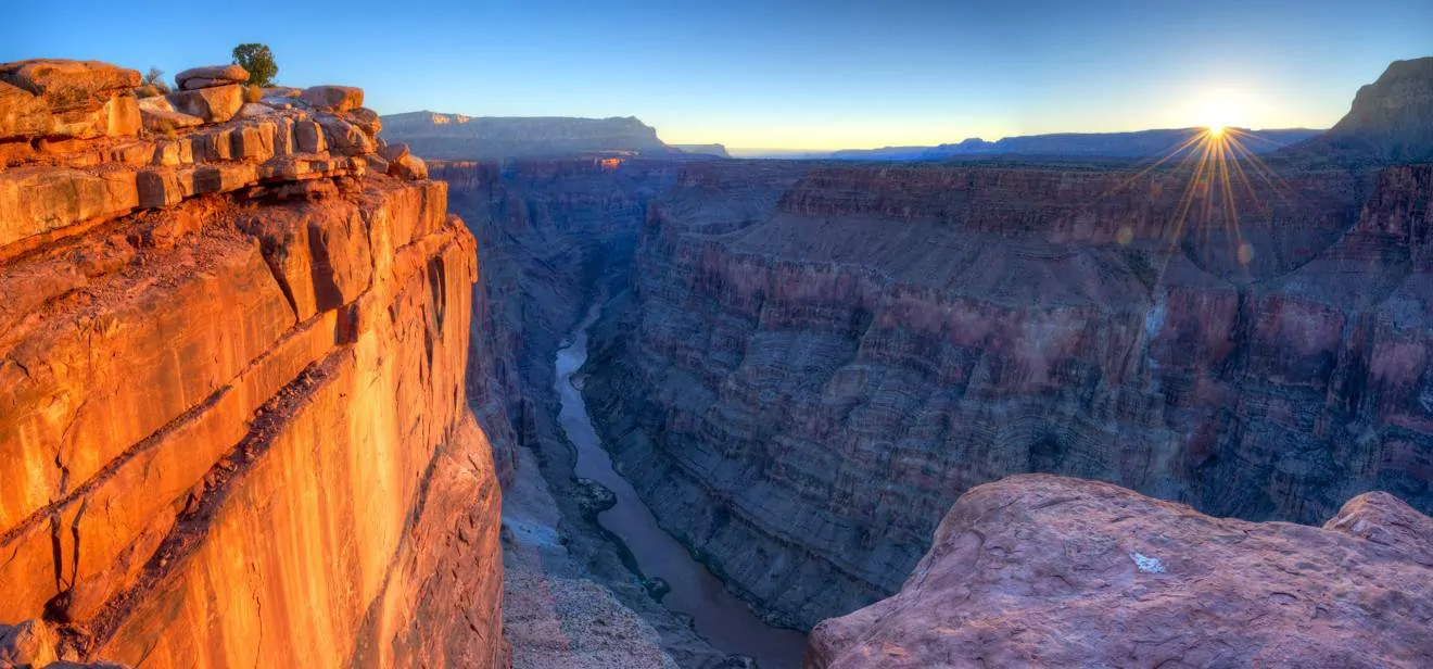
Toroweap Overlook, also known as Toroweap Point or simply Tuweep, is a spectacular overlook, from which you can view the canyon and several volcanic ash mounds and lava flowing from a close position. It is protruding peak 2887 ft above the Colorado River, and it is from here that the Grand Canyon’s most beautiful photographs are taken.
Toroweap Point, unlike the more commonly visited overlooks of the South Rim and North Rim, allows you to enjoy the Grand Canyon for what it really is, a deep, awe-inspiring gorge carved out by erosion caused by Colorado River.
The name Toroweap derives from the Paiute word meaning “barren valley,” while Tuweep (meaning “land”) was used to refer to the settlement of Mormon pioneers who settled in the area.
The presence of the earliest human settlements in the area dates back to the Ice Age when nomadic tribes of hunters settled here in search of a milder climate. Around 2,000 years ago, the Ancestral Puebloans, also known as the Anasazi, practiced agriculture in this part of the Grand Canyon. The first documented Westerner to visit the Toroweap Point area and map it was John Wesley Powell in 1870.
How to Get to Toroweap Overlook
This wonderful overlook is located in a remote area of the Grand Canyon North Rim and your spirit of adventure will be tested as you try to drive there. There are no facilities (no gas, food, water, hotels or phones) in the area and the road will be very challenging.
Attention: Due to the increasing popularity of the site, for safety reasons, it has become necessary to limit the number of people visiting. Therefore, obtaining a daily permit or a Backcountry Permit is now mandatory to access the Toroweap Point area.
1. How to Get to Toroweap Point by Car
Before studying the route in detail it is good to make something clear. Not only is the road unpaved but also uneven (especially in the last 2 miles) and you can only access it with a 4×4. The official website recommends that you stock up on fuel, take along your car jack, an air compressor and tire caps (in case of flat tires).
If it rains the ground could become muddy and you must be very careful, because if you are forced to get rescued it could cost you between 1000 and 2000 dollars… and anyway apparently it is not guaranteed!
If reading this has dampened your spirits, skip directly to the next section below, to find out how to visit Toroweap Overlook on a tour, otherwise, if you are still interested, continue reading.
There are 3 main routes to Tuweep, which can be accessed from AZ 389, between Fredonia (Arizona) and St.George (Utah). You should budget at least two or three hours of driving and rely on a printed map, as the GPS signal in this area is easily lost.
- Sunshine Route: the most reliable route. Exit the AZ 389 8 miles west of Fredonia or 6.2 miles east of Pipe Spring National Monument. This 61 mile road has sharp rocks, gravel and dust. Be sure not to stop to take a break on the reservation when on the route.
- Clayhole Route: Exit AZ 389 into Colorado City, Arizona. This road is 56 miles long and impassable when wet.
- Main Street Route: This 90-mile scenic road is inaccessible in the winter due to snow and mud.
2. Alternative Method: Take a Tour
Given the challenging level of the route, many might understandably choose to go on a tour instead. Here is a link to provide you more information and also details about booking:
Toroweap Point Tour
- Dreamland Tours
- Inquire for information on the Utah tourism website
Excursions and Trails in the Area

Surely stopping to admire the view from the Toroweap Overlook is in itself a unique experience worth the effort of getting there; however, once you arrive, you can also explore many other beautiful overlooks by going on hiking trails, such as the Tuckup Trail, which may be particularly interesting for those who are fascinated by the geology of the area, the Saddle Horse Loop Trail, which offers spectacular views of the Colorado River, and the Whitmore Trail, a 4-mile trail that will take you to the bottom of the canyon, right on the river. For more information on these trails, check out the official website.
Overnight Stay
There is a campground near Toroweap Point, but permits to spend the night there must be requested well in advance. The only alternative is to sleep in nearby cities, such as Colorado City and Hildale. You can check out the accommodation in the area by clicking on the link below.


Why do you say: not to stop or take a break on the reservation?
Hello David, this is a rule of the National Park Service U.S. Department of the Interior.
I think there is a difference between Toroweap Point and Overlook. Toroweap Point is a place high above the campground on the tip of a finger like projection above the cliffs soaring over the campground and area. Am planning to attempt an off-trail hike/scramble to Toroweap Point when I visit the area in April. There is no beta on the route, so who knows whether or not we will be successful.
Hi, yes. Technically Toroweap Point and Toroweap Overlook are two different places, but we usually use “toroweap point” to refer to the area of the Grand Canyon where the overlook is located.