During your road trip, are you planning to travel between Yosemite National Park and Death Valley, two of the California’s most famous national parks? In that case, an exhilarating drive on Tioga Road full of spectacular views awaits. On the other hand, you will have to take into account that this is not a short drive and that you must plan well. For this reason, most of the West Coast itineraries include just a few quick stops (Bodie, Mono Lake, and Mammoth Lakes are the most popular), especially if you don’t have much time.
Yet, as you can read in the article about attractions in the Eastern Sierra, there are plenty of places to explore on the eastern slopes of the Sierra Nevada. One of them is Alabama Hills. If you have extra time on your way from Yosemite to Death Valley, go visit Alabama Hills – I guarantee you won’t regret it. In this article, I’ll help you figure out how to best organize your trip.
Contents
About Alabama Hills National Scenic Area
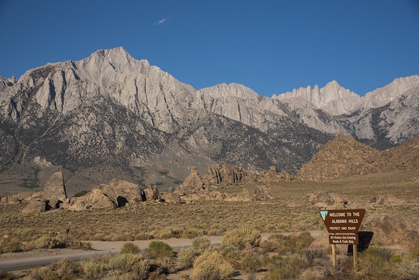
The Alabama Hills National Scenic Area is under the protection of the Bureau of Land Management (BLM). Admission is free. The Alabama Hills extend into a desert area on the slopes of Mount Whitney, the tallest mountain in California and the contiguous United States. The views from Alabama Hills make a visit all the more memorable.
How to Get to Alabama Hills
Alabama Hills is located in California, a few miles west of Lone Pine, the last town on US-395 before the turn for Route 136 and for CA 190, the road that leads into Death Valley. This location makes Lone Pine a very convenient and strategic stop for those who want to stay overnight near Death Valley on the way from Yosemite. Keep in mind that the distance from Lone Pine to Yosemite Valley is still considerable (200 miles).
From the North
If you are coming from the north (Yosemite) you have two options:
- The easiest and most common way to get to Alabama Hills is to drive to Lone Pine and turn right at the only traffic light in town onto Whitney Portal Road. After a few blocks, you will be leaving the town and heading towards Alabama Hills. The directions below show the road from Bishop to the entrance of Whitney Portal Road, but you can follow the same directions if you begin anywhere on US 395 S.
- There is a second option. 4 miles past Manzanar, turn right towards Moffat Ranch. From this junction, you’ll have to travel about 7 miles on a well-maintained dirt road to reach the Alabama Hills. Make sure to follow your GPS carefully (there aren’t many signs). This route is not as popular as the other, but it is more adventurous and theoretically a more “logical” choice if you are coming from the north. If you decide to access Alabama Hills from here, you’ll have to take the route recommended in this article in reverse order.
From the South
If you are traveling the opposite way, from Death Valley (or Las Vegas) to Yosemite, simply follow the directions in the opposite order. If you are coming from Los Angeles, you will have to take CA 14-N towards Palmdale-Lancaster until it joins US-395 N. Then you will have to drive to Lone Pine. Once you reach Lone Pine, follow the directions I gave above.
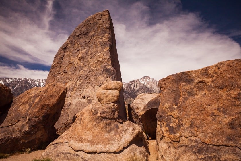
Alabama Hills: Hiking Trails and Things to Do
Below you will find trails, rest stops, places of interest, and scenic spots to go to while visiting Alabama Hills. Follow our itinerary step by step and you will have an adventure and discover the strange rocks in the Lone Pine area. As I have already mentioned, if you are coming from Moffat Ranch, follow the itinerary in reverse order.
Nightmare Rock
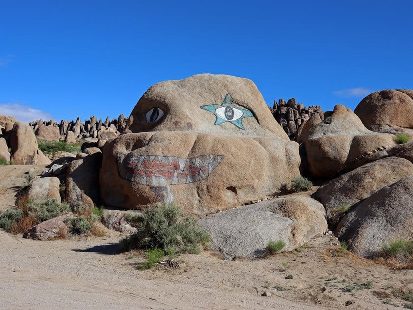
You will continue past Lone Pine, and after you pass the sign welcoming you to the Alabama Hills National Scenic Area, the road will begin to climb the rocky hills. Gradually you will become familiar with the layout and you’ll see the mountain peaks in the background. Stop here and take the side road. You will notice a large painted rock known as Nightmare Rock. Take a picture with this rock, but keep in mind that the next time you come back it may look different. Nightmare Rock’s features have been known to change, so the picture above may be out of date!
Alabama Hills Movie Road (Junction)
Half a mile past Nightmare Rock, turn right and take Movie Flat Road, where most of the sights are located. What is the reason behind the name? As we’ll see in a moment, the distinctive scenery here has been the setting for many westerns and sci-fi movies.
Shark Fin Loop
After driving a little while, you’ll have your first chance to stretch your legs a bit on a short, easy trail that offers remarkable views. The Shark Fin Loop is a 1.7-mile loop trail that anyone can do. You’ll find clusters of oddly shaped stubby and pointed rocks here and there along the way, but the most interesting one is undoubtedly the one that gives the trail its name, and you’ll see it shortly after leaving the car. It’s the massive shark fin-shaped rock right next to the trail. When you reach it, you may choose to turn around, but the whole loop won’t take too long.
Lone Ranger Canyon
Get back into your car and drive for 0.25 miles. On the right, you will see a dirt road that leads to a very fascinating place known as Lone Ranger Canyon. This is one of the most fun places in this area. Think of this kind of canyon as a dense agglomeration of large rounded boulders that create a thrilling labyrinth of tunnels, dead ends, bottlenecks, and narrow corridors. If you have a good sense of direction and you know how to use a GPS, you can drive on the dirt road to return to Movie Flat Road through the canyon, or leave the car in the clearing at the entrance of the canyon and go on foot to explore. T
his location is the perfect place to stage an ambush, or to hide from people chasing you. Perhaps this is why so many western movies, including the one that gives the canyon its name, were filmed here. While you are here, you should also look out for Gene Autry Rock, an unusual rock made famous by the Hollywood actor of the same name. These are the coordinates for Lone Ranger Canyon. The video below shows some clips from the various movies filmed here.
Bowling Ball and Pins and Hidden Window
Given the abundance of rock climbing spots, many rock climbers like to come to Alabama Hills, especially the western side of Movie Flat Road. If you are not a fan of rock climbing but you still enjoy seeing and photographing “rocks that look like other things”, drive to this spot. While rock climbers have fun rock climbing, you may see a rocky bowling ball with its pins (3-minute walk) you will also find the Hidden Window, a strange rock formation shaped like a shell. Through the hollow space in Hidden Window, you can see the scenery and take a picture. Here are the coordinates.
Arch Loop Trail

After seeing the Bowling Ball and Pins, head back to Movie Flat Road and head to the Arch Loop Trail, the most popular area in Alabama Hills. On this short trail, you’ll find some remarkable rock arches with surreal shapes that will undoubtedly catch your eye. It may not be as grand as Arches National Park, but the views of the arches are still remarkable. One of the arches on this trail is Möbius Arch, the famous sinuous arch that looks like something out of a Dali painting. The shape resembles the Möbius Ribbon. This is undoubtedly the most famous and beautiful arch in the area, but there are two others.
- Lathe Arch is located close to the Möbius Arch, but it is a little harder to find. When you arrive, you’ll see that this small, narrow arch is a perfect natural frame for the Sierra Nevada mountains in the background.
- Heading back to the car, almost at the conclusion of the loop, you will see Heart Rock, a rock with a heart-shaped cavity. Here’s the location.

Eye of Alabama Arch

After completing this trail, get back in your car and continue driving down Movie Flat Road. A little over a mile past the parking lot, if you pay close attention, you’ll see the Eye of Alabama on your right hidden among the boulders. If you want to get a closer look at this arch, park your car on the side of the road at this side road on the right. There is no marked path to the Eye of Alabama, and you will have to climb a bit to get closer. Never lose sight of it, and use your GPS to get around!
An Unforgettable Picture
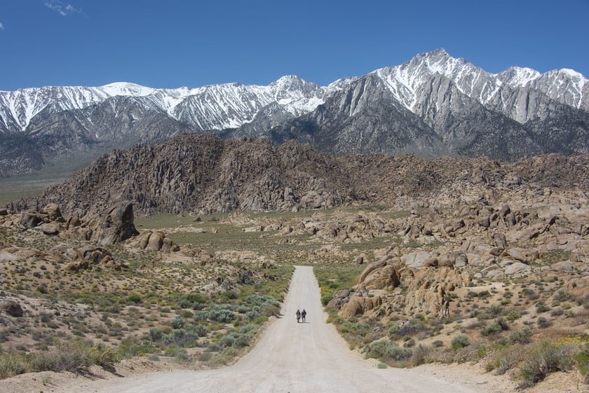
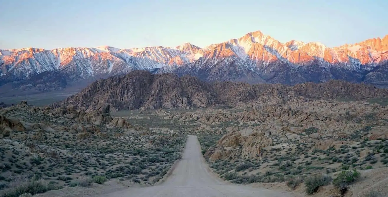
Return to your car and continue driving uphill on Movie Flat Road for 0.4 miles. Stop the car at this point and enjoy the view of the rocky landscape crowned by the Sierra Nevada Mountains. Have you seen the photo above? What about the cover photo in the article? Would you like to take a similar one? If you take a picture of the road from the top of the hill (perhaps at sunrise!) with the rocks in the foreground and the mountains in the background, you’ll get a few thousand likes on Instagram. Guaranteed. This viewpoint is so striking that it was used for a famous scene in Iron Man (2008).
Boot Arch and Cyclops Skull Arch

Along with the Möbius Arch, there are other unique arches in Alabama Hills. However, they are not as easy to get to. Moreover, being located in the northern part of the natural area, they are the farthest from Lone Pine and, if you want to reach them, you’ll have to invest a little more time. If, on the other hand, you decide to enter from Moffat Ranch, these will be the first arches you may encounter. You will just need to take a small detour from the main itinerary.
But let’s go back to the classic route described so far. Once you pass the hill featured in Iron Man, drive on Movie Flat Road for another 1.7 miles. On your left, you will see a secondary dirt road. It’s in pretty good condition. Keep driving (drive very slowly if you have a sedan or another vehicle without all-wheel drive or four-wheel drive, or avoid it if you don’t feel safe!) and stop the car at this point. Using the GPS, drive for 5-10 minutes until you reach Boot Arch (use this location to find it), an arch with a very unusual shape. Picture a sleeping giant with his leg bent and his boot resting on the surface. Drive for another 5 minutes on this road and park your car in one of the clearings on the right (for example, this one). There you will see Cyclops Skull Arch, perhaps the most beautiful arch in the park.
How do you find this beautiful double skull arch? Once again, walk northeast and enter this destination in your GPS. It won’t take long if you have a good sense of direction.
Map of the Attractions
Best Time to Visit Alabama Hills

The ideal seasons to visit the Alabama Hills are spring and fall. If you go in the summer, be sure to protect yourself from the heat, especially if you want to hike the short trails shown here, which are all exposed to the sun. In the winter, it can get very cold.
Where to Stay

If you’ve decided to devote a half-day or more to the Alabama Hills, the best place to look for accommodations is Lone Pine.
If, on the other hand, Alabama Hills is just a stop between Yosemite and Death Valley, read our tips in our article that talks about where to stay between Yosemite and Death Valley.
Alabama Hills Movies
So far, we have only mentioned The Lone Ranger and Iron Man, but there are many movies that were filmed here. Some of the more recent movies include Tremors, Django Unchained, Star Trek Generations, Maverick, Gladiator. Alabama Hills has also been the setting for many classic movies, such as Gunga Din (1939), Yellow Sky (1948), and The Conquest of the West (1962).
If you would like to have fun exploring the places where these movies were set, follow the directions on this map.
Trivia
What does Alabama have to do with the rocky hills in California? Nothing! The name comes from the C.S.S. Alabama, a warship of the Confederate States of America. It was chosen by gold miners in the area who sympathized with the Confederate cause during the Civil War.