Along with The Narrows and Zion Observation Point, the trail leading to the top of Angels Landing is considered one of the best in Zion National Park. The view from the ridge of this monolith is one of the most photographed in the park. Compared to the other two hikes mentioned, however, it is famous not for being the most strenuous, but it is undoubtedly the most breathtaking. I could have said “dangerous”, but I don’t want to scare you right at the beginning of the article. I’ll talk about the danger of Angels Landing in more detail later in the article.
Contents
Where is the Trailhead, Hike Length and Time
- How to get to Angeles Landing? To get to the West Rim Trailhead, you need to use The Grotto shuttle stop. The actual Angels Landing Trailhead is located at the end of the West Rim Trail, at the Scout Lookout.
- How long is Angels Landing hike? Angels Landing is a tiring 5.3-mile hike (round trip) with a total elevation gain of about 1640 ft.
- How long does it take to hike Angels Landing? The walk can take 2 to 4 hours depending on how much of the trail you decide to climb.
Actually, the hike should be divided into 2 parts:
- West Rim Trail to Scout Lookout: 2-mile route with 1066 ft elevation
- Angels Landing Trail: 0.7-mile route with 557 ft elevation
Reservation
From 1 April 2022, reservations will be required to get on Angel’s Landing. You need to pay 6 dollars (the fee covers an application for up to 6 people) + 3 dollars per person. See this page for the seasonal lottery dates. Check out the video below to see how to make a reservation.
To get an overview of all the other American parks that require reservations, I invite you to read our dedicated article.
Angels Landing Hike via West Rim Trail
West Rim Trail
The hike starts near The Grotto shuttle stop. Once you get off, go to the Virgin River and cross the bridge. At this point you will find yourself at a fork in the road: on the left is the Kayenta Trail, which leads to the Emerald Pools (Upper and Lower), on the right is the West Rim Trail towards Angels Landing. After a first short flat stretch along the river, you will start to climb a paved trail, along hairpin bends that are completely exposed to the sun in the morning. This climb is very tiring, especially in the final part, as you approach the entrance to Refrigerator Canyon and the hairpin bends are steeper and narrower. From time to time, turn around to the Zion Canyon and as you climb up and you can see the beautiful panorama widening more and more.
The part of Refrigerator Canyon is a little more relaxing. After crossing a small bridge, you will walk along the eastern face of the canyon on a paved path with a very slight slope, in the shade of the towering red cliffs and the rich vegetation, which create a beautiful contrast. Along this intermediate route, you will also find a recess in the rock where you can climb to take some photos.
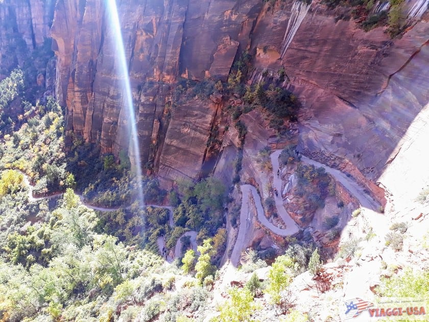
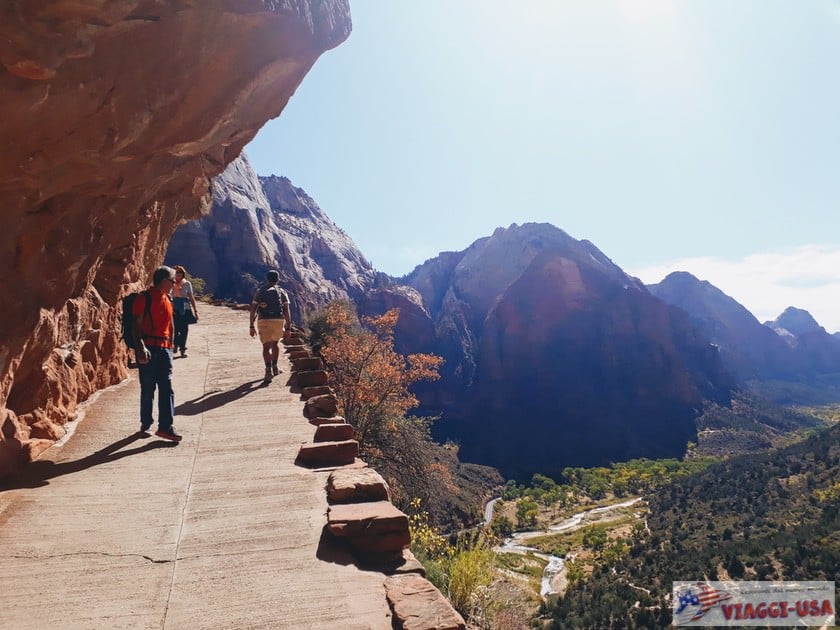
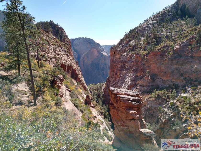
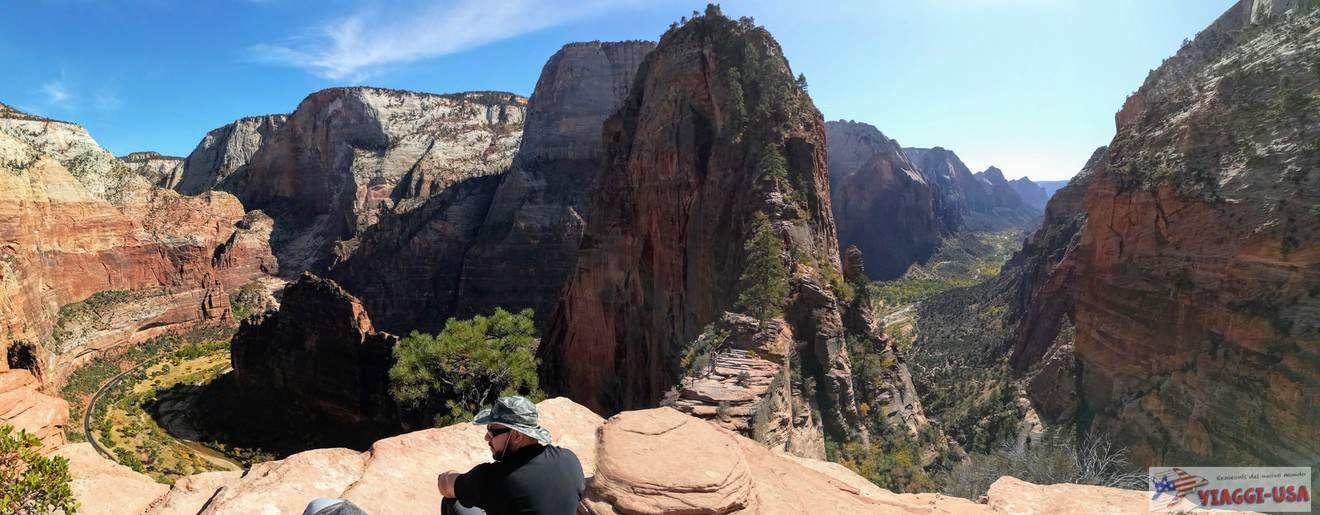
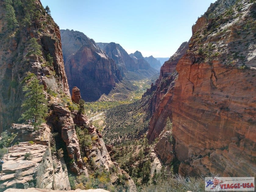
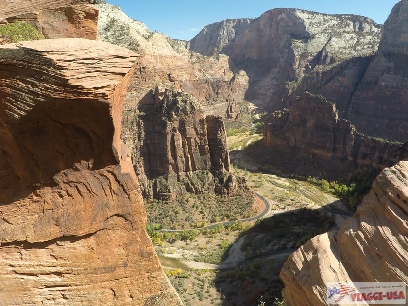
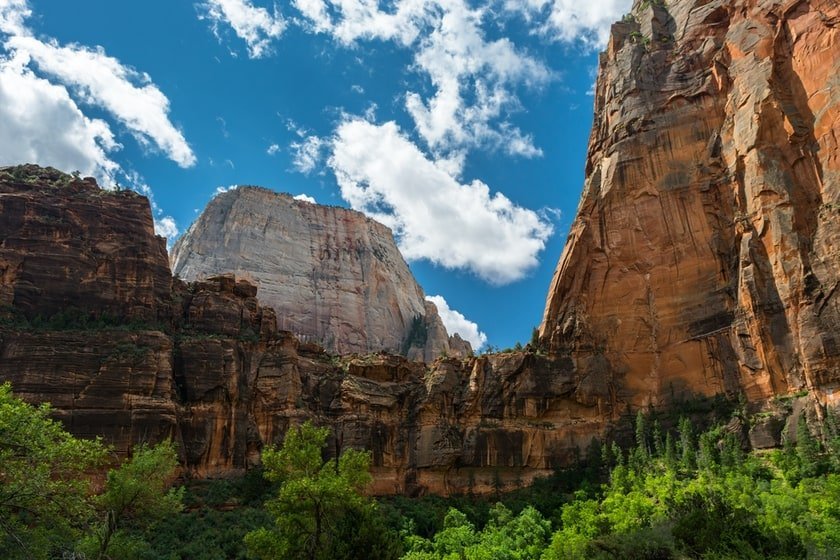
At a certain point past the Refrigerator Canyon, there will be a turn in the path where you will come upon one of the most renowned points of the trail, that is, the famous climb called Walter’s Wiggle. This series of 21 very narrow and steep switchbacks is named after the man who designed this ascent in 1926, Walter Ruesch, the park’s first historic superintendent. This grueling serpentine trail leads to the end of the West Rim Trail to Scout Lookout, from which you can enjoy a beautiful view of the park, with a remarkable view of The Organ and the unmistakable Angels Landing rock formation.
From this point on, you can choose whether to continue hiking the Angels Landing Trail or go back on the same West Rim Trail.
Angels Landing Trail
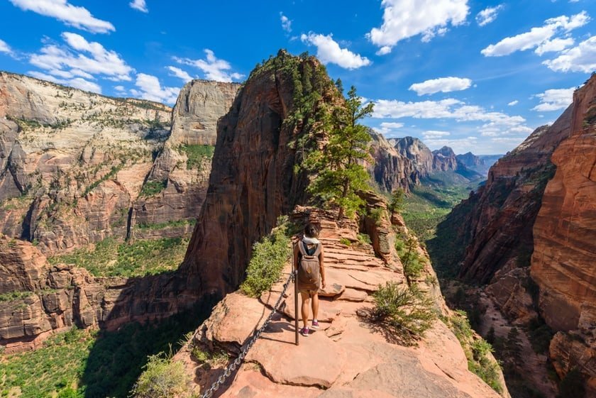
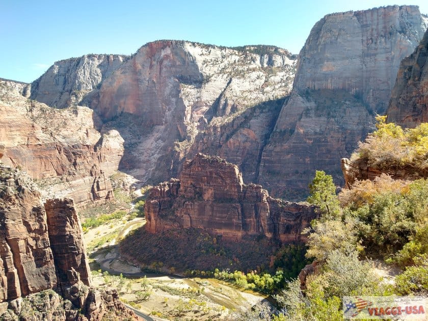
The Angels Landing Trail takes place on the eastern edge of the Refrigerator Canyon, where you have been walking until now, and it concludes at the end of the slope, at an altitude of 5790 ft above sea level, offering an incredible view of Zion Canyon. The name of the hike speaks for itself. When Methodist pastor Frederick Vining Fisher saw the top of the cliff, he told the superintendent Walter Ruesch that only an angel could reach it.
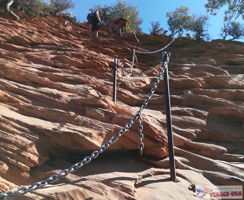
But why do many people decide to turn back? In fact, because the last part of the trail is so challenging, not everyone gets to the top. The Angels Landing Trail runs along a narrow ridge, completely exposed on the cliff. Throughout the trail, you will climb up the rock with the help of chains attached to the rock and, in some cases, you have to let people go in the opposite direction by breaking away from the chain.
How Dangerous is Angels Landing?
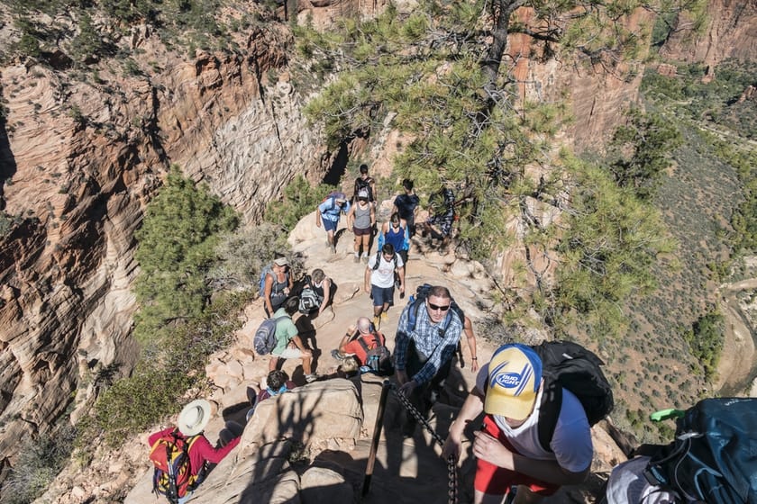
Since 2004, 8 people have died falling during the ascent. This can certainly be frightening, but I would like to say that, although it is an impressive hike, with a bit of courage and a certain athletic predisposition, Angels Landing can be done, unless the conditions of the trail don’t allow it. Rangers advise not to attempt the final part of the hike when the trail is covered in snow or when the weather forecasts rain and wind. Obviously, it is advisable to wear suitable clothing for hiking. Needless to say, this hike is not recommended to those who are afraid of heights.
Angels Landing View from below: The Big Bend Viewpoint
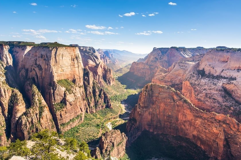
If you don’t feel like doing the hike or don’t have time to do it, you can see Angels Landing from the Big Bend Viewpoint, which is located right on Zion Canyon Scenic Drive, at the shuttle stop of the same name. From the bottom of Zion Canyon, Angels Landing appears to be a huge rock face that cuts through the valley (following a wide bend in the Virgin River) that stretches across into another rock formation called The Organ. Behind you will be the Touchstone Wall, while in the background in front of you will see The Great White Throne.
Angels Landing View from above: Zion Observation Point
Well yes, you can see the soaring Angels Landing from the top of Zion Observation Point. If you want to know how to get there (and it’s not easy), read our trail guide.
Where to stay to hike Angels Landing?
To answer this question, I suggest you read our in-depth review of the accommodations in Zion National Park, where you will find tips for Springdale, the town of reference, and all the others in the surrounding area.