Choosing to drive from Sequoia National Park to Death Valley (or vice versa) is quite common especially during the time of year when the Tioga Pass is closed and it becomes practically inevitable for those who have to cross the Sierra Nevada from west to east (or vice versa). Clearly, this is not the only reason for traveling between these two destinations. There are also those who, when faced with the tough choice between Yosemite and Sequoia, have decided to visit Sequoia and, therefore, skip visiting Yosemite. Consequently, after visiting Sequoia, to continue the tour and reach Death Valley, there is no need to return to Yosemite to take Tioga Road. Instead, one must bypass the Sierra Nevada from the south via Bakersfield, one of the landmarks on this trip.
Although the journey is not complicated, we have received a lot of questions about how to organize the trip between Death Valley and Sequoia and where to stay overnight, because the drive between the two places is long and, what usually happens is that travelers have little time and even less energy after visiting the parks. Moreover, this part of California doesn’t have many “roadside attractions”, which can make the trip a bit boring. But let’s take a closer look to see how you can plan this trip.
Contents
Death Valley to Sequoia National Park: Driving Distance and Routes

If you use Foothill Visitor Center and Stovepipe Wells as your landmarks, the distance between Sequoia and Death Valley is about 300 miles, which takes at least 5 hours and 15 minutes. This means that it is virtually impossible to cover this route on the same day you visit Sequoia National Park. Therefore, it is necessary to look for an intermediate stop to spend the night while bearing in mind some important criteria:
- We always advise against driving more than 5-6 hours in a single day.
- Due to the “hellish” climate of Death Valley, especially in the summer, the ideal thing to do is to arrive there no later than mid-morning.
In light of these points, my first piece of advice is to try to reduce as much as possible the distance between Sequoia and the previous destination. For example, if you are coming from San Francisco or Yosemite, find accommodations in Fresno, Visalia or, better yet, Three Rivers, so that the distance by car to the park the next day is as short as possible.
In this way, you will have two advantages. You will be able to start exploring Sequoia in the morning, and in the early afternoon, you will be able to drive as close as possible to Death Valley.
Tips for finding accommodations near Sequoia
What is the Best Route? 2 Options
From Sequoia to Bakersfield, the only option is to take SR 65. Then from Bakersfield, there are essentially two ways to get to Death Valley:
The most direct and fastest route
From Bakersfield, take SR 58 E until Exit 167 towards Bishop/Mojave. From here you will need to drive to Bishop along SR 14 N road to Olancha or take the exit earlier to Ridgecrest/Inyokern (SR 178 E) and then drive to Panamint Springs. To get to Death Valley from Panamint Springs, you can only take SR 190 E (for about 31 miles).
The longest and most scenic route
Compared to the one just mentioned, this option is just 7.5 miles longer and adds 20-30 minutes more to the travel time, but the route has curves and hills and the landscape is definitely more interesting. From Bakersfield, head east on SR 178. The road runs through the Sequoia National Forest and the most scenic part is the winding section along the Kern River all the way to Lake Isabella. From the lake (not a particularly beautiful reservoir), go towards Bishop on SR 14 N/US 395 until you arrive in Olancha (you can also pass through Ridgecrest/Searles Valley, it is the same distance). The important thing is to reach Panamint Springs and Death Valley.
WARNING! If you want to take the scenic route (SR 178 E), refuel in Bakersfield, because you won’t find many gas stations on the way to Death Valley. The only gas station after Bakersfield is in Mountain Mesa.
Where to Stay between Sequoia and Death Valley?
As I was saying, if you plan well, ideally you can reach Ridgecrest, which is the largest city southwest of Death Valley. Here you will find everything you need and there are several motels of the most reliable chains, making this the best place to stop after such a long journey. Ridgecrest is 196 miles away from Sequoia National Park (Foothill Visitor Center), which means it would take just under 4 hours to get to Sequoia. From Ridgecrest to Stovepipe Wells it takes about 1 hour and 40 minutes (96 miles).
Accommodations available in Ridgecrest
If it is not possible to arrange your trip in this way, or you think it is too long and tiring after a visit to Sequoia National Park, my advice is to stop in Bakersfield (93 miles from Sequoia, just under 2 hours), leaving the longest part of the trip to the next day, knowing that it will be difficult to get to Death Valley in a short amount of time. More precisely, it is a 202-mile drive in just under 3 hours and 30 minutes to get to Stovepipe Wells.
From Death Valley to Sequoia: What You Should Look Out For
In case you are traveling on this route in the opposite direction, you have to take into account that visiting Death Valley can be a bit more tiring compared to Sequoia, also because of the long trips inside the park and exposure to scorching temperatures.
So, if you want to reach Bakersfield for an overnight stay in order to get as close as possible to Sequoia, all the more reason to minimize the travel distance from the previous stop by spending the night in Death Valley itself or near the park. I often read about itineraries that include the trip from Las Vegas to Death Valley. In my opinion, visiting Death Valley and driving to Bakersfield on the same day is overkill! It would be much better to stop at Ridgecrest and postpone the longer leg of the trip until the next day.
Points of Interest: Some Interesting Pit Stops

If you are planning to give yourself plenty of time on the road or you want to add an intermediate overnight stay in order to take a full day to move from one park to another, why not visit some interesting destinations to enrich the experience along the way? As I said earlier, there are not many attractions, but by taking short detours from the main route, you can reach hidden gems unknown to most people.
Trona Pinnacles
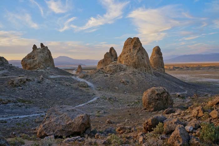
Trona Pinnacles are absolutely the best natural attraction that can be found along the route, so I often recommend going there even if there is not much time. Let’s say you have visited Death Valley in the morning and in the early afternoon you are already on your way to Sequoia. Why not take a couple of hours to visit Trona Pinnacles, since they are located near Ridgecrest? It would definitely be more complicated to reach them at the end of the day for those who come from Sequoia and decided to drive straight to Ridgecrest. Well, why not go to Trona Pinnacles early in the morning before going to Death Valley?
If you’re wondering what to expect, let me tell you. We’re talking about an isolated desert area with impressive white tufa towers that create a landscape out of a science fiction movie. In some ways, it is not too different from Mono Lake. To reach this area, you need an adventurous spirit, since it is only accessible via a dirt road. It’s not complicated, but you have to faithfully follow the directions in my article about Trona Pinnacles.
Red Rock Canyon State Park

Red Rock Canyon State Park is not very well known by tourists. However, in the world of cinema, it is famous. In the past, it was used as an exceptional natural location for films like Zorro Rides Again, The Big Country, Law and Order, The Ten Commandments, Jurassic Park, and Beneath the Planet of the Apes. I’m not talking about the Red Rock Canyon of Nevada or the Red Canyon of Utah. I am referring to Red Rock Canyon State Park in California, located near Cantil. As a matter of fact, there are red rocks here, just like the ones typically found throughout the Southwest, only we would expect to find them in Utah and Arizona rather than California. This little state park is open from dawn to dusk and it will exceed your expectations.
How to Include Red Rock Canyon State Park in your Itinerary
- If you have decided to take the fastest way following the directions I gave above, you will not have any problems, since the state park will be directly on SR 14 N a couple of miles after Cantil.
- If, on the other hand, you are traveling along the scenic route, you will have to take a detour to reach Red Rock Canyon State Park that is slightly more inconvenient (just under 37 miles round trip). At the intersection of SR 178 and SR 14, you have to turn right towards Mojave instead of Bishop. After that, you will arrive at Red Rock Canyon State Park.
Tips for Visiting Red Rock Canyon State Park
If you don’t have a lot of time to spend at Red Rock Canyon, turn off the main road near the Red Cliffs Natural Area. Continue on this road for a little while and you will arrive at a clearing that is located at the foot of a badland with brightly colored tall ravines. This is a good opportunity to take some pictures and wander around the parking lot. Since this road is not well-marked, click here to see the exact point of Google Maps.
After a few yards, you will turn onto Abbott Drive, a short uphill road that leads to the visitor center near the Ricardo Campground. Here you will begin an interesting scenic loop through a rocky desert dotted with Joshua trees below the impressive ravines that surround this part of the park. This landscape is very similar to Joshua Tree. There are also some hiking trails. If you have time and want to take a walk to enjoy some exceptional views of the red cliffs of the canyon, take the Hagen Trail, which is just over a mile long. The trail starts at the beginning of Abbott Drive, near a dirt clearing on the left.
Ghost Towns: Ballarat and Silver City

The biggest regret of those who wanted to or had to give up taking US 395 along the Eastern Sierra was not being able to visit Bodie, one of the most incredible ghost towns in the West. Many people ask me if there are other ghost towns on the route between Death Valley and Sequoia National Park. The answer is yes, although, they may not be as impressive as Bodie:
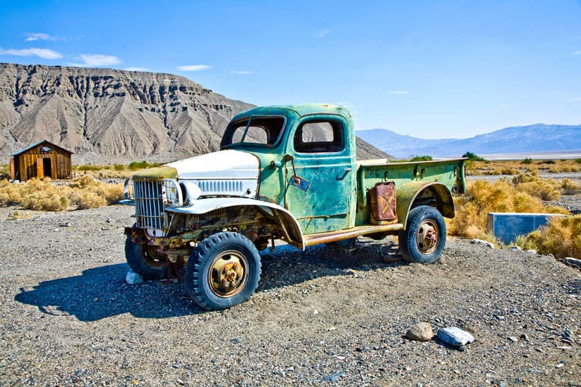
- Ballarat: About 27 miles south of Panamint Springs and 48 miles north of Ridgecrest on Trona-Wildrose Road, turn onto Ballarat Road, a dirt road that cuts through the desert and leads to a charming authentic rundown ghost town called Ballarat. The town was founded in 1897 and abandoned shortly after 1917. Legend has it that the old truck parked among the remaining buildings of the town belonged to the serial killer Charles Manson, although experts dismiss this myth. It is very likely that you will be welcomed by Rock Novak, who since 2013 has been the only inhabitant and “mayor, doctor, judge, sheriff, priest and gravedigger of Ballarat”. He claims that the truck really was Manson’s… I’m not gonna argue with him.
- Silver City: You can only visit this ghost town by taking the scenic route through the Kern River Valley. In Bodfish ( 3829 Lake Isabella Blvd), you’ll find this complex of 21 perfectly restored old buildings that give you an idea of what a Wild West town at the foot of the Sierra Nevada must have been like. You must pay an admission fee to visit the ghost town ($5.50 for adults, $4.50 for children 6-12 years old). Silver City is open every day from 10:00 am to 4:00 pm (closes at 5:00 pm on Saturdays).
Remington Hot Springs

An attraction located on the scenic SR 178 that I want to mention is Remington Hot Springs, which is the only free spa left along the Kern River in the Sequoia National Forest. Until recently, visitors could also enjoy the nearby Miracle Hot Springs near the Hobo Campground, but since they were dismantled, the Remington Hot Springs have become the most popular destination for locals who want to spend some time in a pool of hot water surrounded by nature.
It is easier to reach it from the north (Bodfish) than from the south. You have to take Kern River Canyon Road, a narrow and bumpy asphalt road. From Silver City, you will continue south on this road for about one minute until you reach this point. From the indicated point, you have to follow the road for 5.4 miles, after which you will find a small parking lot on the right and the short trail (0.4 miles) that leads to the small artificial pools carved out of the river. There is little space available and it is a very popular place, so if you want to go there, I suggest that you go early in the morning.
If you are coming from Bakersfield, you also have to take Kern River Canyon Road, but from the southern end by getting off of SR 178 at this exact spot. Drive at a low speed and you will arrive at the trailhead after 7.5 miles, which will take just under 20 minutes.
Tehachapi Loop
Finally, here is an attraction train enthusiasts will love. I suggest that you plan a pit stop in Tehachapi. To the north of this town, there is the “famous” Tehachapi Loop, a spiral railroad track that is the result of an engineering project that has become a National Historic Landmark. There aren’t many other spiral railroad tracks around the world (you can find a list here), so this is a great opportunity, and what makes it even better is that you have a greater chance of seeing a train go through the loop due to the high frequency of trains from Bakersfield to Mojave (approximately 40 trains per day, but I don’t have the train schedule).
Why build a spiral train track? Basically to make it easier for longer freight trains to go through the Tehachapi Pass. By following the loop, the wagons can reach a certain height difference without remaining in a dangerously horizontal position for too long. In the lower part, the train passes under a tunnel. When a long train passes, you can witness the train passing over its own wagons!
Where can you go to see it from an elevated position? Coming from Bakersfield, on SR 58, you will take Exit 139 towards Keene. As soon as you get off the exit, take Woodford-Tehachapi Road (you will see signs for Tehachapi Loop as soon as you get off of SR 58) and drive for just over 3 miles. The best point from which you can see the train is not the one indicated by the two signs on the side of the road. Instead, it is located at the top of the hill. To reach this observation point, you have to climb just 500 ft until the junction with a dirt road blocked off by a chain. Even if the observation point is on private property, the owners of the land allow you to walk up to the top of the hill to see the loop.
Cesar E. Chavez National Monument

The César E. Chávez National Monument in Keene, at 29700 Woodford-Tehachapi Rd, is built in memory of the well known Mexican-American activist who fought for the rights of farmworkers between 1952 and 1976. You can visit the exterior of La Paz, the property of the Chavez family, in particular the pretty and quiet Memorial Garden – where César Chávez is buried – and the small Desert Garden, where you can see plants and flowers typical of the California desert area. Admission is free and the national monument is open every day from 10:00 am to 4:00 pm except on Easter, Thanksgiving, on the Friday after Thanksgiving, on December 24, 25, and 31 and on January 1.