Are you planning a road trip between Arizona and Utah? Maybe you haven’t considered the Navajo National Monument, which is little known but not to be dismissed so easily. You could integrate it as an intermediate stop on your road trip between the Grand Canyon and the Monument Valley, or perhaps between the latter and Lake Powell.
The Navajo National Monument is a small park; it is not comparable to those above and it is rarely featured in classic road trip itineraries. However, its strategic location, halfway between Kayenta, Tuba City and Page, makes it perfect for a short but interesting visit. In other words, even if you don’t have many hours at your disposal, here you can take a break from driving to stretch and to see something really special as well as learn many interesting facts about Native Americans.
Contents
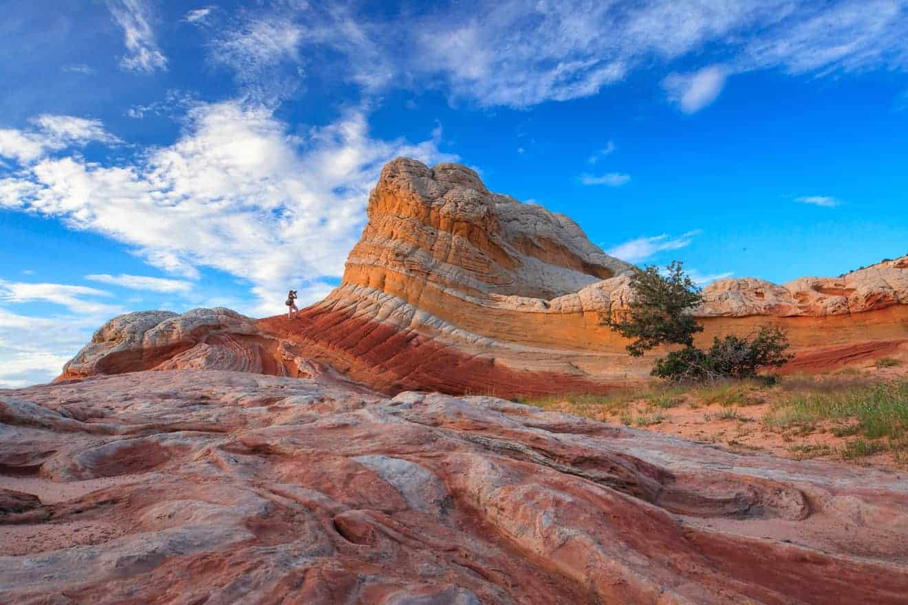
 Navajo National Monument is a protected area created to preserve three cliff dwellings from the 13th century. Blocks of sandstone plastered with mud and mortar make up what today appear as almost surreal ghost towns, embedded in the colossal red rock walls that surround this valley. Settlements built into the rock or built in the large cavities of the mountains are quite widespread in the Southwest. Some of the best-preserved settlements are found in New Mexico, but also in Mesa Verde National Park, Canyon de Chelly or Montezuma Castle National Monument.
Some of the parks mentioned above are undoubtedly more famous than the Navajo National Monument, but this park has a significant feature. It is located in a position that makes it convenient to include it in a classic itinerary. If this is your first time visiting the West Coast, this is the only site where you can see cliff dwellings without deviating from the road trip route to visit the most famous points of interest in Utah and Arizona.
But you will ask yourselves, who lived in these cliff dwellings hidden in the hollow spaces of the mountain? The Anasazi lived there; they were a sedentary people who based their livelihood on the cultivation of corn. Building the houses in these characteristic positions was not only a way to hide and defend their villages, but above all allowed them to make the most of the little cultivable land in the valley in this semi-desert region.
Over time, these settlements were inhabited by different Native American tribes, until white people arrived at the turn of the 19th and 20th centuries, plundering the artifacts preserved in these abandoned houses and gradually turned them into tourist attractions.
 The Navajo National Monument is located in the center of the Page – Monument Valley – Grand Canyon triangle. Its strategic location makes it an ideal stop for those who have just visited Monument Valley and are heading towards the Grand Canyon or Page and Lake Powell, and also for those traveling in the opposite direction. Specifically, it is located at the junction between SR-564 and Indian Route 221, which deviate from the US-160 and SR-98 state roads respectively. Let’s see how to get there from the more famous places in the area.
- From the south (Grand Canyon): Those arriving from the Grand Canyon should follow the signs for Tuba City. Once you have passed the city, continue on US-160, and keep driving until you reach the turn (on the left) for SR-564, which is 8.7 miles from the visitor center. The Grand Canyon is 143 miles away (about 2 hours and 30 minutes driving), while from Tuba City it is 62 miles (about 1 hour).
- From the northeast (Monument Valley): Coming from Monument Valley, you have to reach Kayenta and from there turn right on the US-160 and continue driving until the turn (on the right) for SR- 564, which you have to drive for 8.7 miles to the visitor center. Monument Valley is 51 miles away (about 1 hour) and Kayenta only 30 miles (about 30 minutes).
- From the northwest (Page): Those arriving from Page must follow SR-98 until the turn (on the left) for Shonto. Continue on this road and you will automatically find yourself on Indian Route 221, which you will take all the way to the visitor center.
Itinerary between Monument Valley and Grand Canyon
Map, Hours of Operation and Admission Fee
Admission to the Navajo National Monument is free, but most of it is only accessible during the hours of operation of the visitor center. In addition, guided tours are usually only available during the summer season. In the winter (December-February) some of the trails are in fact impassable due to snow.
Below are the hours of operation of the visitor center:
- Summer (from Memorial Day to Labor Day): 8:00 am to 5:30 pm.
- Winter (from Labor Day to Memorial Day): 9:00 am to 5:00 pm.
- Closed on: 1 January, 26 November, 25 December.
PLEASE NOTE: Although the park is within the boundaries of Arizona, it follows Mountain Standard Time, which is the same time zone as Utah. Please read this article for more information.
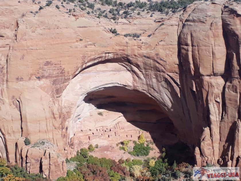
The main attractions of the Navajo National Monument are two cliff dwellings: Keet Seel and Betatakin. It is true that I mentioned earlier that there are three settlements in the park, but the third is closed to the public and is not visible from any of the accessible trails.
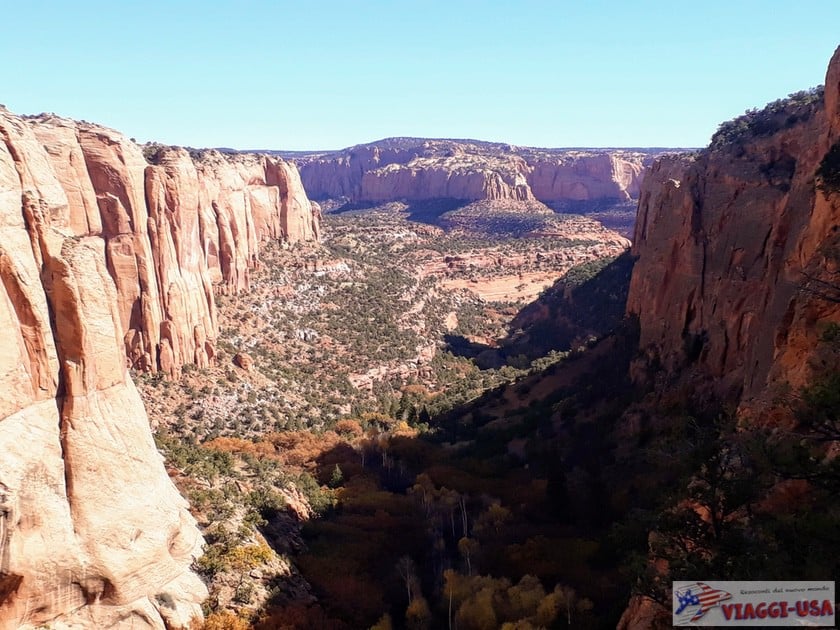
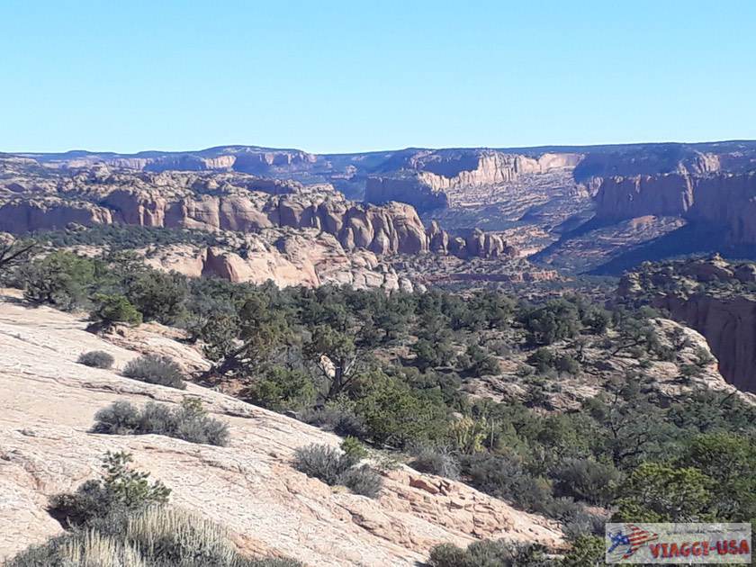
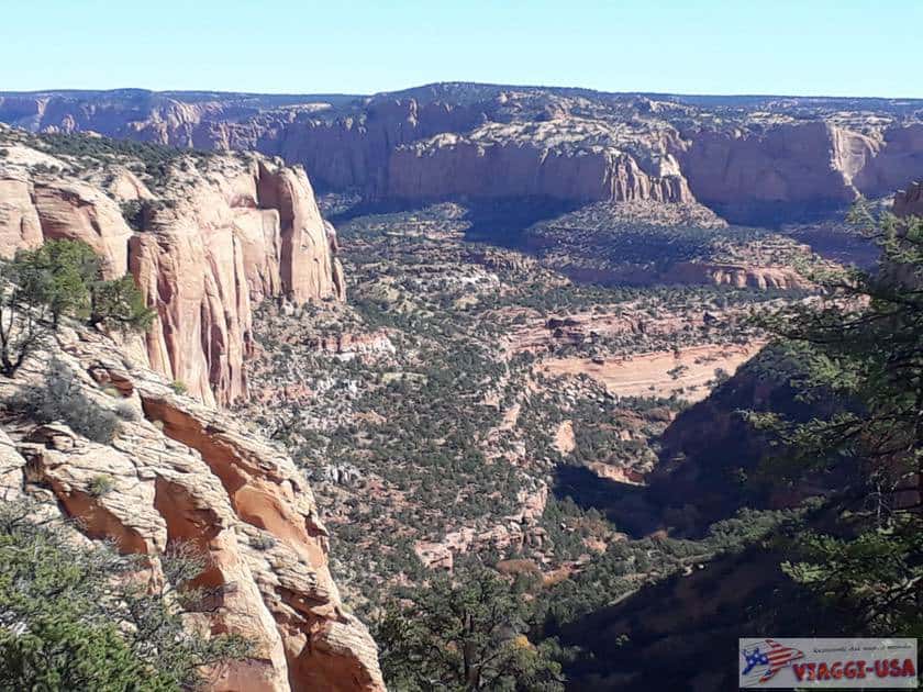
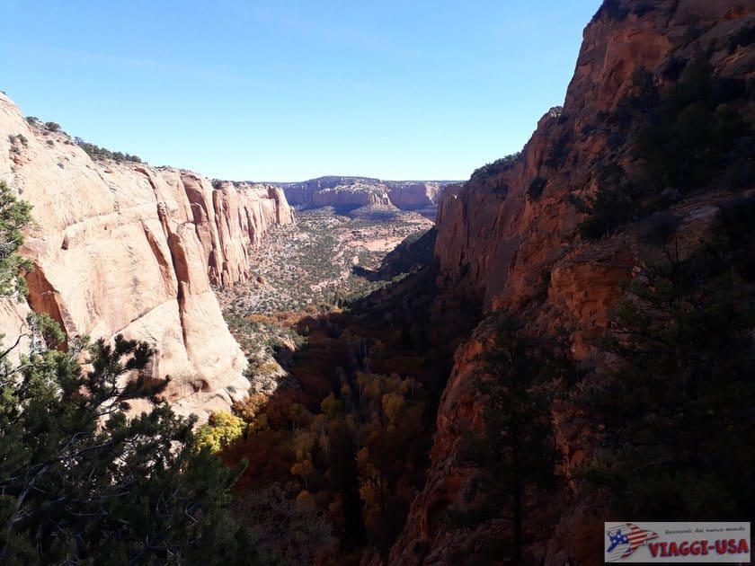
What is most striking is the location of the cliff dwellings, more than the cliff dwellings themselves. Both are nestled in huge cavities in the rock face overlooking a narrow valley. Those who love to admire landscapes will also enjoy seeing the valley, which fills with fog in the morning in the winter and in the summer there is a sharp contrast between the green of the trees and the orange of the surrounding rock faces. It is quite easy to spot many animal species, from the numerous small rodents to the rare mountain lion.
The area of the park can be visited independently by going on three quite short and easy trails, but to reach the settlements it is necessary to rely on guided tours. Below you’ll find more details for these two different tour options, but whatever you decide, I suggest you make a stop at Tsegi Point Overlook, a viewpoint looking over the canyon located along SR-564 on the way to the visitor center.
Estimated Time Needed for the Visit
 I mentioned earlier that the visit to the Navajo National Monument can be considered a quick stop between more popular points of interest, such as the Monument Valley and the Grand Canyon. Indeed, there is the possibility to have a good overview of the park in a very short time, or you may choose to spend more time there and go on a guided tour lasting a few hours.
In a couple of hours it is possible to walk on all three of the proposed trails, while if you choose to only go on one of them, it will take less than an hour. If you are in a hurry, you can decide only to go to the viewpoint along the road and to one of the trails, which you can complete in about an hour or so.
Hiking Trails
The three trails branch off from the visitor center and all of them are quite simple. If you have time, I suggest that you go on all of them to get the best out of the park, otherwise, my suggestion is to choose between the Sandal Trail and the Aspen Trail. The Sandal Trail is the one that gives you the best view of the impressive rocky Betatakin Cliff Dwelling, while the Aspen Trail is the one that leads to the most beautiful view of the entire canyon.

- Sandal Trail. About 2,600 ft (1 mile round trip) long, this is a very simple trail along a paved path and wooden footbridges. It is accessible to everyone and it leads to the only viewpoint where you can see the Betatakin Cliff Dwelling without taking part in a guided tour. You will be on the opposite side of the valley and thanks to binoculars installed on the platform, you will be able to observe a typical example of a cliff dwelling from afar.
- Aspen Trail. At a certain point not far from the visitor center, this trail deviates from the previous one. It is just over 1,968 ft (0.8 miles round trip) long, but compared to the Sandal Trail it is mostly unpaved and has a steep downhill section at the end. It leads to the Aspen Forest Overlook, which is located exactly at the end of the canyon, where you can see the narrow valley.
- Canyon View Trail. The last trail starts at the visitor center and heads away from the other two trails in the opposite direction. This one is also 1,970-2,300 ft long. It runs alongside the edge of the canyon and offers a good view of the valley below.
Those interested in learning more about the place, or physically reaching one of the cliff dwellings, can go on a guided tour. Please note that during the winter the tours are either less frequent or not take place at all, depending on the weather conditions. In general, it is suggested to do them in the summer season.
- Betatakin Tour: Group tours depart at 7:00 am and at 8:15 am from Betatakin (town). On this tour, you will travel 5 miles in about 4-5 hours, so you will have to set aside the whole morning if you intend to take part in the tour. It is definitely one of the best ways to visit the park, since it gives you the possibility to cross the canyon and go all the way to the settlement in the company of rangers who will explain the history of the place and share fun facts along the way.
No reservation is required, but a maximum of 25 people at a time can go on the tours with the rangers (if you are traveling in a group, contact the visitor center in advance). - Keet Seel Tour: This tour is over 17 miles long, making it a much more challenging tour. The elevation gain isn’t significant, but what makes it demanding (in addition to the number of miles) are the sandy areas, which must be crossed at a slower pace, and sections where you have to walk in the water. It is a very beautiful trek, but it is only recommended for experienced hikers. It is certainly not suitable for those who are going to the park for a quick visit. In any case, you can only access it with a ranger, so it is mandatory to book at least one day in advance and the number of people admitted daily is limited. If you are willing to go on this tour, please inform yourself ahead of time on the official website.
Where to Stay Nearby
If you opt for a fairly short visit (without taking advantage of the long guided tours), which is likely the case, you will be passing through here and on the same day you will visit other parks, cities, or attractions in the area. Depending on the direction of your itinerary, the ideal place to spend the night may vary. The nearest town is Kayenta, which is on the way to Monument Valley. By clicking on this link, you will find all the hotels available in Kayenta, but I also recommend you to read our article about where to stay in Monument Valley. If you go in the opposite direction, going towards the Grand Canyon, you will find Tuba City. You can either check out the hotels in Tuba City, or follow our advice on where to stay near the Grand Canyon. Finally, if you are heading to Lake Powell or Antelope Canyon, read our recommendations on where to stay in Page.