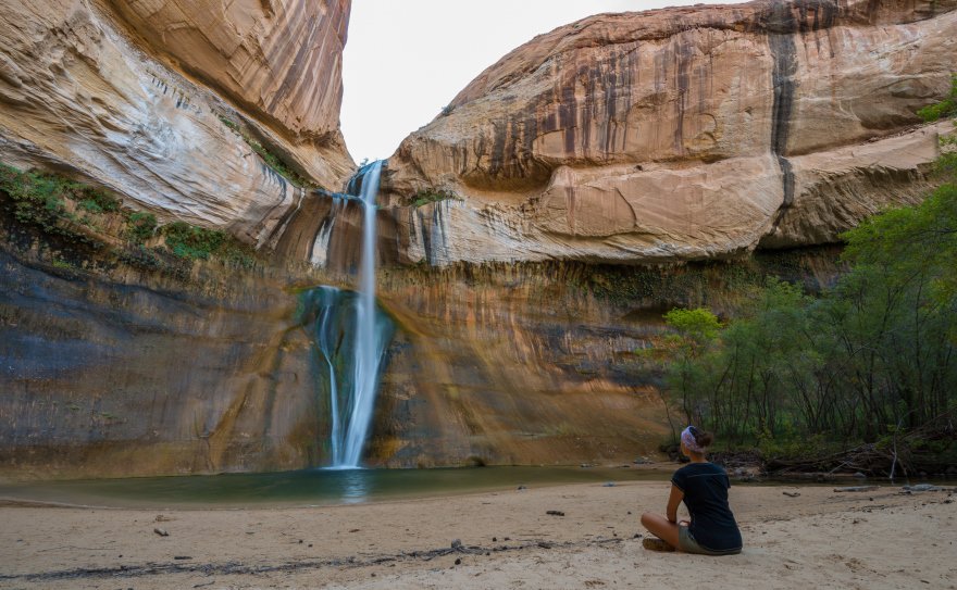
It is delightful to see water flowing into a creek in the middle of a canyon surrounded by desert. And when you see this enchanting sight comes into view after a few hours of walking under the scorching sunshine, you will hardly resist the urge to dive into the clear water.
If you are planning to travel on UT-12 during your road trip itinerary of Utah or perhaps several states in the Southwest, you might consider spending a few hours hiking to some really beautiful waterfalls that flow from Calf Creek, one of the tributaries of the Escalante River.
Contents
Directions to Calf Creek Falls Trail
The trails that lead to the waterfalls, both Lower and Upper, branch off from UT-12, the scenic road that crosses the Grand Staircase-Escalante National Monument. Specifically, they are located in the stretch of UT-12 between the town of Escalante and Boulder.
The entrances of the two trails are not well marked, so I suggest you refer to the following Google Maps links:
- Parking to access the lower falls (note: in this case, the parking lot is located by a campsite and costs $5 per vehicle);
- Parking to access the upper waterfalls.
Lower Calf Creek Falls Trail

- Length: 6 miles round trip
- Elevation Gain: 518 ft
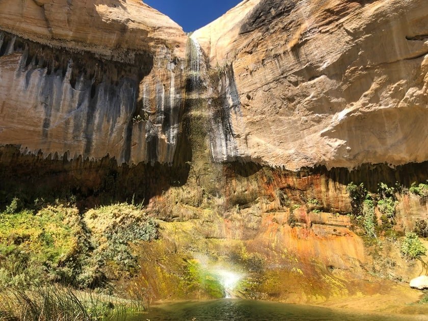
Lower Calf Creek Falls are one of the most popular attractions in the vast Grand Staircase-Escalante, or at least one of the most frequented by visitors interested in one-day hiking tours. The main waterfall of Calf Creek Falls, which is over 125 ft high, flows into a plunge pool in a beautiful spot where the canyon suddenly sinks. In the summer, when it gets hot, many of those who come here after a few hours of walking to take a swim in the cool water under the waterfall.
The trail is a little less than 3 miles long (about 6 miles round trip) and normally it is good to give yourself between 3 and 4 hours to get there and come back. The trail itself is quite simple, but some parts that require walking in the sand can be tiring and it is also one of the reasons why it is better to wear hiking shoes than sneakers, which fill up more easily with sand. In general, this route suitable for everyone, even children, but you still have to take into account the weather conditions on the day of your visit (walking for hours in the sun in the middle of summer is not the best).
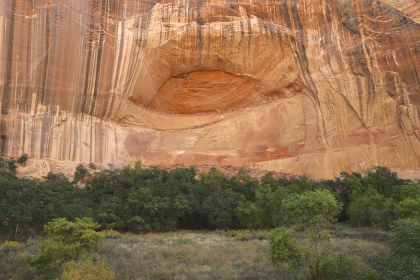
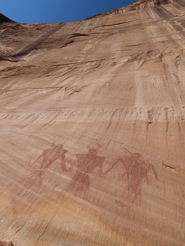
The trail follows the course of the stream at the bottom of the canyon, but the waterfall at the end of the trail is not the only reason it’s worth going on this hike. Along the way, you will find a large cave carved into the rock. It is a kind of granary built more than 800 years ago that was used by the inhabitants of these canyons at the time to store their food. Another piece of evidence that confirms that the area was already inhabited many centuries ago is a petroglyph representing three human figures.
What makes this trail also interesting is the wildlife that you can see. Many different species of birds fly between these sloping rocks. If you are lucky, you’ll be able to see a magnificent peregrine falcon, otherwise, you’ll still be able to see robins or other small birds. In the stream, it will not be difficult to spot some beavers building a dam, while along the trail you may see a mule deer appear.
If you want to download the pdf of the official brochure made by the Bureau of Land Management, which is really very detailed and well done, you can find it at this link.
Upper Calf Creek Falls Trail
- Length: 2.2 miles round trip
- Elevation Gain: 604 ft
If you are an experienced hiker, you may prefer a more challenging trail that is not crowded and gives you the opportunity to enjoy a series of waterfalls that, although they may not be as tall as the ones mentioned above, also provide a nice view and an area where you can swim.
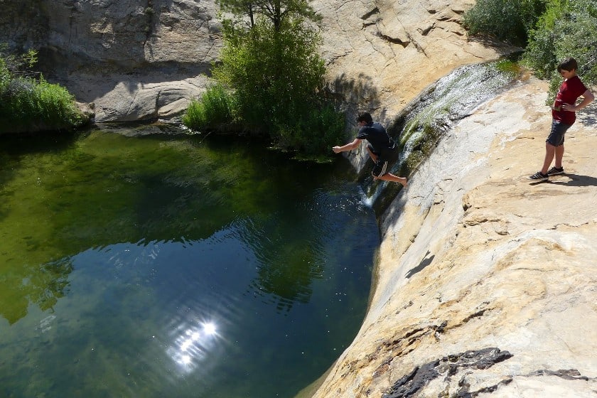
Upper Calf Creek Falls are a series of waterfalls that are more varied, though they are shorter than Lower Calf Creek Falls. The highest waterfall is 89 ft high, but there is not much water streaming down. Not far away, however, you will find a series of smaller waterfalls that pour into natural plunge pools where it is pleasant to swim and easy to dive from the surrounding rocks.

The trail to reach these waterfalls is shorter, but not as accessible as the one to the lower waterfalls. For this reason, you won’t find that many hikers compared to the number of visitors on the other trail during the high season. Although it is less than 2 miles round trip, the path down from the road to the canyon is quite steep. You may find the trail to be difficult in some places, both downhill and uphill, because the rocks are steep and slippery.
Upper or Lower? Which Waterfalls Should You Choose?

UT-12 is one of the most beautiful scenic roads in Utah. For this reason, I suggest you take the time to discover all the beautiful places along the way. If you love hiking, you will certainly be open to devote half a day to a hike to one of the waterfalls of the stream that runs parallel to the state highway.
At a certain point, you will ask yourself, is it better to go to the lower or upper waterfalls? In part, the answer comes from your hiking experience. The trail to the Lower Falls is a long but easy route. This is why they are the most popular with visitors. If you have enough time and don’t want to venture on a trail that is too demanding, choose the Lower Falls.
The Upper Falls, on the other hand, can be reached via a shorter, but much more challenging trail. This hike is recommended for more experienced hikers, who are not afraid to cling to the rocks somewhere and venture into very steep sections of the trail.
If, on the other hand, you don’t have the time or the desire to walk, you can certainly park your car and stop for a few minutes at the Calf Creek Viewpoint. This will at least allow you to take a nice picture of the canyon as seen from above (but you won’t see the waterfalls).
Where to Stay Nearby
We’re talking about an area within Grand Staircase-Escalante, so don’t expect to find the same variety of accommodations offered in a big city nearby. Considering, however, that you will most likely be stopping here on a trip that also includes other destinations along the UT-12, I suggest you read our recommendations on where to stay along the UT-12, where you will also find accommodations closer to Calf Creek Falls.