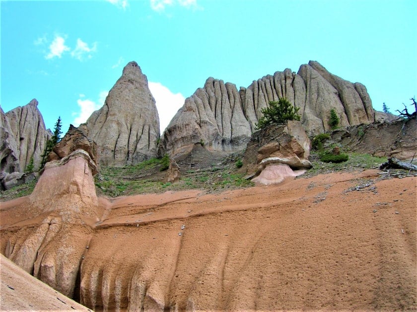
Also known by many as the City of Gnomes, the Wheeler Geologic Area is located in Colorado, within what is called La Garita Caldera, a crater that formed some 28 million years ago as a result of one of the most violent volcanic eruptions on Earth. This is certainly among the most unique views that can be observed on a road trip in the United States. So let’s find out everything you need to know about the Wheeler Geologic Area.
Contents
What is the Wheeler Geologic Area?
As I mentioned above, the origin of this area can be traced back to a volcanic eruption. Over the years, the ash released from the eruption compressed and created porous and highly erodible rock formations. Wheeler’s hoodoos and strange spires resulted from erosion over time. In 1908, in order to protect this area, Colorado’s first national monument was created at the behest of President Theodore Roosevelt.
It was named Wheeler National Monument in honor of George Wheeler, who worked for the U.S. Army Corps of Topographical Engineers. He did extensive geological surveys of the area between 1873 and 1884. Several other natural attractions in the United States have also been named in honor of Wheeler, for instance, Wheeler Peak in Nevada in Great Basin National Park.
Where is it located? How do you get there?
To start, getting to Wheeler Geologic Area is unfortunately not that straightforward. In fact, if you want to get there on your own, you will have to drive a 4×4 off-road vehicle with high ground clearance. Also, the trails that take you to Wheeler Geologic Area are very long and strenuous, making it almost impossible to do a day hike. To reach the area, first, you will have to drive along Colorado 149 to the intersection with Pool Table Road (also known as U.S. Service Road 600) and continue for 10 miles until you reach an area called Hanson’s Mill Campground.
From here you will have basically two options to choose from: either take the East Bellows Trail, a trail about 8.7 miles long (one way), or continue along the road to the campground for almost 14 miles (one way) along with other off-road vehicles going to, or returning from, Wheeler. Keep in mind, however, that the route that continues from Hanson’s Mill is a narrow dirt road that branches between ravines, and muddy and rough terrain that can suddenly get worse in many places. Obviously, things become much more complicated during, or shortly after rain and snow storms.
If you have the right kind of transportation and are willing to venture out, before embarking on the hike, stop by the Divide Ranger District in Creede (304 South Main St.), where you will be able to get updates on the current road conditions and get useful advice. As I said earlier, most people would not consider this a day hike both because of the length of the journey and because of the sights to be seen along the way and once you reach your destination. However, since there are no campsites with amenities, only primitive ones, the hike is recommended only for those who are experienced hikers.
Things to See

Once you get near the Wheeler Geologic Area, you will realize how small, but also how spectacular, the area in which these bizarre rock formations are concentrated is. In addition to admiring the one-of-a-kind views, you can take a short trail of about two miles around the rock formations to admire them from multiple angles.
Where to Stay in the Area
The best places to look for a hotel in the area are in Creede and South Fork (where you will find a much greater selection). But there are also many accommodations along the CO-149 road. You can still get an overview of the best places in the vicinity by clicking on the link below.