Today we are talking about an unjustly underestimated destination in California, especially when you realize that it is so close to San Francisco. For those who love cliffs overlooking the sea, Point Bonita Lighthouse offers much more than just a visit to a historic lighthouse. Here you can walk peacefully to the end of a promontory that stretches out over the open sea and admire a remarkable panorama that stretches from the Golden Gate Bridge to the stacks of the Northern California coast.
And the surroundings are not bad either. The entire Marin Headlands region boasts some nature trails that might tempt you to explore the whole area more thoroughly. Let’s see how to organize a visit to the lighthouse at Point Bonita and surrounding attractions.
Contents
Location
 Point Bonita Lighthouse is located in Point Bonita, a promontory in the Marin Headlands, a hilly peninsula in Marin County, the same region where Muir Woods and Sausalito, classic day trip destinations from San Francisco, are located.
In addition to having scenic attractions, the Marin Headlands also have a significant military past and are part of the Golden Gate National Recreation Area protected area, whose boundaries are quite extensive (including the Presidio, the Golden Gate Bridge, and the air north of the Bay to Bolinas Ridge, which runs parallel to the San Andreas Fault).
How to Get to Point Bonita from San Francisco and Surroundings

To get to the lighthouse, you’ll need to take a short trail over the cliff. The entrance is accessible by car or bus.
By car
If you’re coming from San Francisco (south) you’ll have to cross the Golden Gate Bridge (you don’t pay the toll northbound) and then take Exit 442. Coming from the north, the exit to take on the 101 is the same.
Point Bonita Parking
There is a small parking lot (Bonita Lighthouse Parking) close to the trailhead, if you can’t find a parking space (which is likely since it has only 10 parking spaces) you can search for parking at Bonita YMCA Point or Battery Alexander Parking, respectively 3 and 5 minutes walking from the previous parking lot.
By bus
From San Francisco, if you want to reach the entrance to the lighthouse trail, you can take the 76X Marin Headlands Express, which stops right at Bonita Lighthouse Parking. However, this bus only operates during the weekend. The line to San Francisco (Downtown) runs from 10:30 am to 6:30 pm, while the line to Point Bonita (Marin Headlands) runs from 9:30 am to 5:00 pm.
Also, remember that the bus stops at the lighthouse only in the direction of Marin Headlands, and to return to San Francisco, you’ll need to use the Bunker Rd & Field Rd bus stop, located 0.6 miles away from the trailhead of the Point Bonita trail (so consider this additional distance before taking the bus to return to San Francisco).
Travel time from San Francisco
- By car: From the entrance of the Golden Gate Bridge to the entrance of the trail to Point Bonita Lighthouse, it takes approximately 15 minutes, traffic permitting.
- By bus: About 40 minutes from Union Square, or about 20 minutes from the Golden Gate National Recreation Area entrance.
A Short History of the Marin Headlands Lighthouse
 The lighthouse at Point Bonita was built in 1855 during the Gold Rush to prevent more ships from crashing into the coast as many had over the years (more than 300). Initially, its location at 305 ft above sea level made it ineffective, as the high fog banks of the Pacific coast covered the light.
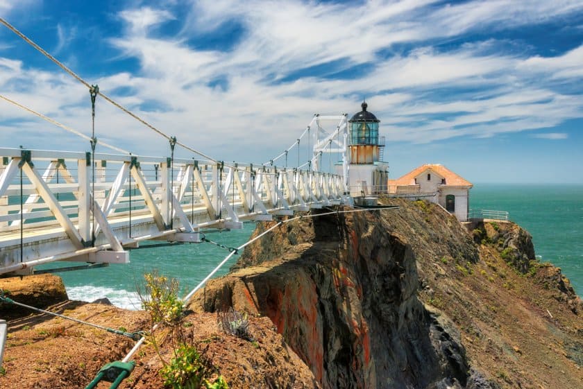
In 1877, it was moved to its present position (118 ft above sea level) and, in order to cross the cliff, a 118-ft long tunnel was dug into the rock and a walkway was created, which is still one of its most characteristic features today, together with its position overlooking the sea.
Point Bonita Lighthouse Hike
 As I mentioned earlier, to get to enjoy the view, you will have to walk a short and easy trail that is 1 mile round trip. The trail is asphalted, so it’s easily accessible for everyone, and passes through the tunnel dug in the rock that was previously mentioned.
The walk along the promontory is immediately very beautiful, especially for the many views it offers of the cliffs, but the best views can be enjoyed from the bridge and the lighthouse, where you can see the typical stacks of the Northern California coast. Along the trail, you’ll clearly see the Golden Gate Bridge, which appears as if it were the background of a painting.


Would you like to visit the lighthouse? Unfortunately, it is only accessible on Sundays and Mondays from 12:30 pm to 3:30 pm, or during guided tours held by rangers that require registration.
The Marin Headlands and the Surroundings
As I already mentioned, Point Bonita is part of the Marin Headlands, an area where you will find both natural and historical points of interest. While driving or even walking along this hilly peninsula, you will often come across the remains of fortifications and military settlements.
This is because, since the end of the 19th century, this area has been used on several occasions as a fort by the military, which built bunkers and fortifications here for the 2 World Wars and the Cold War. Many of these historical remains are actually reduced to rubble and have easily become prey to graffiti.
However, some of them have been preserved and turned into museums, such as the Nike Missile Site SF-88, a missile launch site built during the Cold War (check the official website to find out the hours of operation).


A short distance from the lighthouse there is also a series of nature trails and viewpoints. The nearest trail can be taken directly from the parking lot of Point Bonita. This is the starting point of Mendell Road, a path that runs along the coast, crossing Battery Mendell and leading to another beautiful ocean view (and if you want you can continue the walk to Rodeo Lagoon Vista Point).
Hawk Hill, the highest point of the Marin Headlands, is a privileged vantage point for the observation of birds of prey, especially hawks, eagles, and vultures, which are easily spotted from here in the period from August to December.
Battery Wallace, on the other hand, provides the perfect setting for those who have always dreamed of having a nice picnic in the open air with superb views of the Golden Gate Bridge (look for Bicentennial Camp Picnic Area). Finally, Rodeo Beach is a long beach nearby connected by a bridge to the homonymous lagoon.


In the area, there is also the Marine Mammal Center, whose mission is the rescue and rehabilitation of marine life (it can be visited for free or you can book a paid tour on the official website).
These are just a few tips, but there is much more in the area. For a more comprehensive overview stop by the Marin Headlands Visitor Center.
Further away, still in Marin County, there are the two most famous attractions of the area: Sausalito and Muir Woods. For more information on these two places, please read our in-depth articles:
- Sausalito: A charming coastal city on the San Francisco Bay
- Muir Woods National Monument: The redwood forest near San Francisco
Where to Stay
 In 90% of the cases if you decide to visit Marin Headlands it is because you are in San Francisco, so I suggest you read our advice on the best neighborhoods to find accommodations in the city (with some recommended hotels), but if you are one of the few who want to spend more time exploring Marin County, then a hotel in this area, out of the hustle and bustle of the city, that could be what you are looking for.
In this case, the nearest areas where to look for accommodations are Sausalito and Mill Valley. Take a look at the hotels and prices by clicking on these two links: