On the border between Utah and Arizona, near Page, there is a secret geological treasure that is worth visiting, where you can be awe-inspired by the natural beauty just as you were when you visited the national parks scattered in the surroundings. We are talking about Paria Canyon-Vermilion Cliffs National Monument Wilderness Area, a rare and remote natural area waiting for you to explore it.
Contents
- Vermilion Cliffs and Paria Canyon: What to Expect
- Directions to Vermilion Cliffs
- Vermilion Cliffs in 4×4: All the Most Adventurous Roads and Trails
- Coyote Buttes, a Gem Hidden in the Canyon
- The Wave, the Natural Wonder of Coyote Buttes North
- Coyote Buttes South: Two Recommended Trails
- White Pocket
- Last Tips
Vermilion Cliffs and Paria Canyon: What to Expect
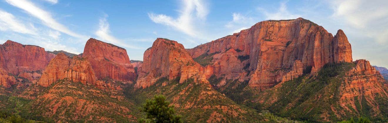
Vermilion Cliffs National Monument is a very high escarpment that dominates a vast desert area, with its sandstone walls, sheer slopes, and cracks that lead to dark tunnels deeper and deeper into the rock. The other point of interest in the area is Paria Canyon, a majestic desert “museum” through long corridors below tall red rock walls, arches and terraces, and through galleries and natural amphitheaters along the Paria River.
It is in this part of the Paria Canyon-Vermillion Cliffs Wilderness Area that you are likely to find the most incredible trails. This landscape may remind one of Antelope Canyon, but it is unique in its own way. Finally, I must also mention Coyote Butte, a spectacular area, although there are strict restrictions in place for visiting it. I will talk more in detail about it later. You may consider obtaining a special permit so that you can sleep inside Paria Canyon. There is a limit of 20 people per night. This is the address. There is no visitor center near Paria Canyon.
Directions to Vermilion Cliffs
How do you get to this place that is hidden yet full of treasures? Surely, because it is such an isolated place, you cannot easily make a quick visit here and then move on to the next stop. An afternoon will not be enough to visit these places in this area.
In case you don’t have an off-road vehicle and want to reach the Vermilion Cliffs Monument, here are the possible routes to get there:
- If you are coming from Flagstaff, you will take Highway 89 north to Bitter Spring, where you will turn onto Highway 89A, which will take you to the heart of Vermilion Cliffs and Paria Canyon, the two central points of this section of the Colorado Plateau;
- If you are coming from Kanab, take Highway 89 eastbound or Highway 89A southbound and pass through Fredonia and Jacob Lake.
Vermilion Cliffs in 4×4: All the Most Adventurous Roads and Trails
If you have an off-road vehicle, there are several alternative ways to access the meanders of Paria Canyon. All the routes start on Highway 89, which we’ve talked about so far, and they all end at Paria Contact Station. Be careful, because the routes described below require not only the appropriate means of transport, but also a great deal of skillful driving, the right gear for camping and, above all, a lot of time!
White House Trailhead
- From Page, drive 30 miles west on Highway 89. You will find Paria Contact Station, which is your landmark and the last “frontier” where you can venture on a long hike. The trail begins after two miles of dirt road;
- From Kanab, drive 43 miles east on Highway 89. Then follow the directions above.
The trail from here joins other trails after 21 miles (Wire Pass Trailhead) and 38 miles (Lee’s Ferry Trailhead). There is also a campground.
Wire Pass Trailhead
- From Page drive 34 miles west on Highway 89. Pass the Paria Contact Station (for all the routes, this is the last chance to get water), turn left onto House Rock Valley Road. The trailhead is after 8.3 miles of dirt road;
- From Kanab drive 38 miles east on Highway 89. Then follow the directions above.
The trail then joins other trails after 5.7 miles (Buckskin Gulch Trailhead) and after 44 miles (Lee’s Ferry Trailhead). There is also a campsite. The main trail to Coyote Buttes North also starts here, which we will talk about later.
Buckskin Gulch Trailhead
From both Page and Kanab, follow the directions to the Wire Pass Trailhead road we have just provided. You will find the trailhead after just 4.5 miles of dirt road. Buckskin Gulch is famous for being the longest “slot canyon” in the Southwest. It is about 25 miles between roundtrip and is definitely one of the top trails in this area. Of course, you can also reach it from the other trails mentioned here. The longest distance between Buckskin Gulch and another trail is 47 miles (Lee’s Ferry Trailhead). You can camp along the trail in the authorized areas.
Lee’s Ferry Trailhead
- From Page, drive south on Highway 89 for 25 miles. Take Highway 89A and continue for 14 miles. You will see the Glen Canyon National Recreation Area on your right;
- From Kanab, drive east on Highway 89 for 73 miles to Page. Then follow the directions above.
From here, you will embark on a long trail that crosses other trails. It will take 38 miles to reach the White House Trailhead and 47 miles to get to the Buckskin Gulch Trailhead. The campsite in this area has certain restrictions.
Coyote Buttes, a Gem Hidden in the Canyon

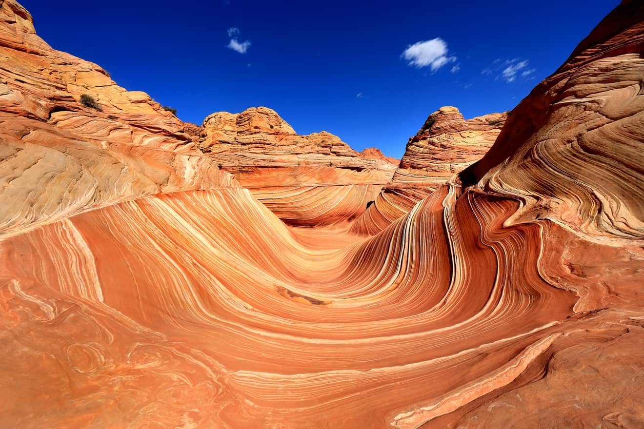
Coyote Buttes (in the two parts North and South) is the most famous section of the canyon and also one of the wildest and pristine. There are several reasons you may be interested in going to Coyote Buttes. Besides the ancient bizarre rock formations (The Magic Crest looks like it was carved by a visionary sculptor), you’ll also find The Wave, a surreal landscape with hypnotic lines undulated on perfectly polished rocks, and dinosaur tracks. Time here has stood still. a place out of time, which has remained so.
For this reason, entry into this area is regulated, and you are required to buy a permit. When choosing the trail you want to venture on, you will also have to take into account that the number of daily permits is limited. You will find all the information here. Furthermore, camping is not allowed in this area. You will have to return to Page or go near Paria Contact Station.
The Wave, the Natural Wonder of Coyote Buttes North
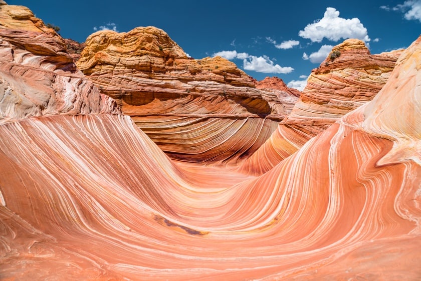
First of all, in order to access Coyote Buttes North, you need a permit. Between March and November, only 10 permits are given out each day. If you have a permit, go to the Wire Pass Trailhead, which we have already talked about earlier. This route will also take you to the famous The Wave. To find out how to reach the trailhead, please read the directions already provided above.
You will arrive at The Wave after about 3 miles of walking from the beginning of the trail. A GPS navigator could be useful, but we recommend that you pay close as you walk, because you will have to rely on your visual memory to find your way back on this hike that takes about 1.5-2 hours.
Here is a video that can give you a better idea of the type of hike that awaits you.
Coyote Buttes South: Two Recommended Trails

To access Coyote Buttes South, we recommend these two trails. Trails is not the best word to describe them, because, for the most part, they are not marked. For this reason, I recommend these trails to expert hikers, because they require a strong sense of direction and experience walking on trails in extreme conditions. Here are the details.
Paw Hole Trailhead
To reach the beginning of the trail, you’ll need to go on House Rock Valley Road, which we talked about in the Wire Pass Trailhead section. From here, you’ll have to drive south on a very bumpy road (be careful, it requires an off-road vehicle and, if it has rained or is raining, it’s impassable. Always check the road conditions at Paria Contact Station) for 16 miles to Buckskin Gulch, then turn left and continue for almost 2 miles on a sandy road. From here, you will take a moderate trail that is about 3 miles long. As I have already mentioned, the trail is only accessible to those who have a permit.
Cottonwood Cove Trailhead
This trail also starts on House Rock Valley Road. You’ll have to follow the same directions and the sign for the trail will be on the road. Although the trail is slightly shorter (about 2.4 miles), it still requires you to pay attention to where you are going, because the way is not clearly marked. You will also need a permit to enter this trail.
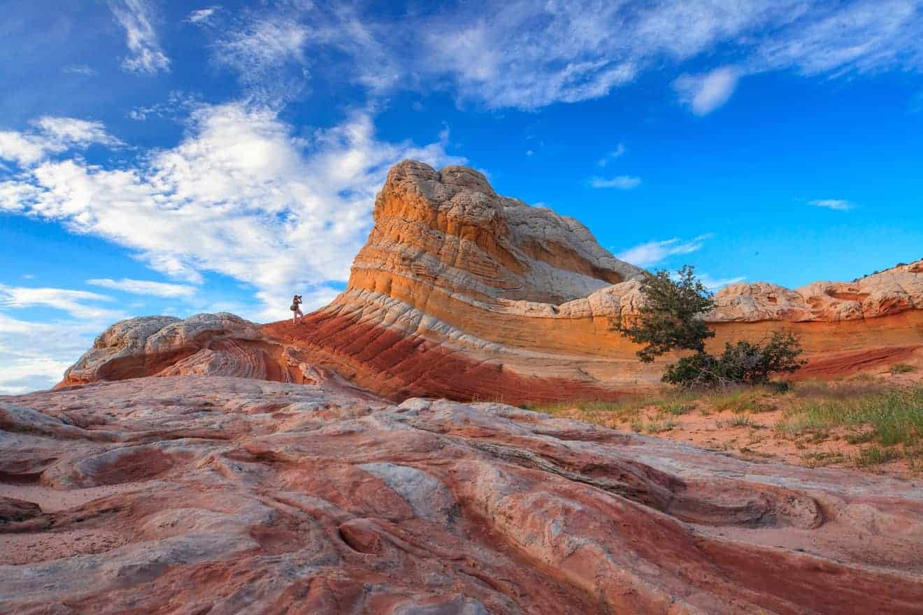
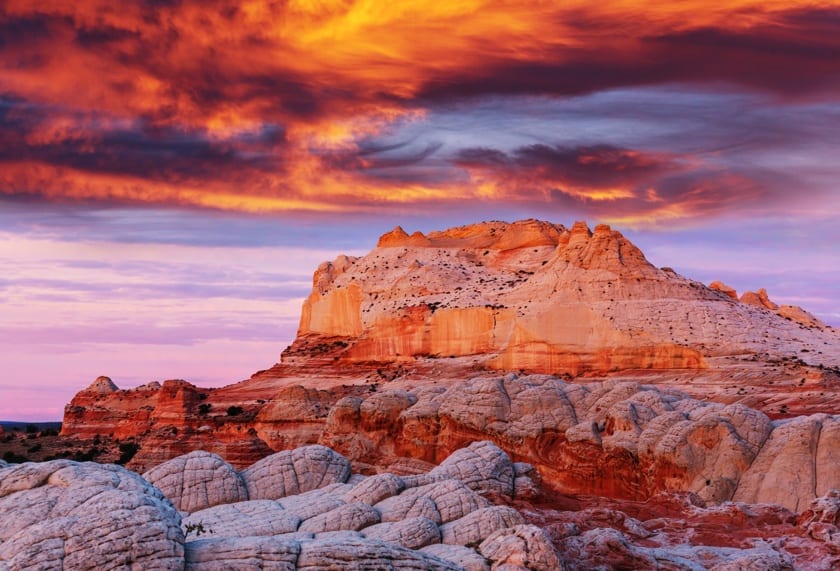
White Pocket

In the heart of the Vermilion Cliffs, there is also White Pocket, a remote and rugged desert area where the erosion process caused by weather events has transformed sandstone and clay rocks, creating a multicolored landscape with absurd rock formations. The great advantage of White Pocket is that it does not require a permit, but the flip side is less exciting: the road to reach it takes a lot of time and requires a 4×4 vehicle. In our article dedicated to White Pocket, we provide advice and information on both guided tours (very popular) and self-guided visits.
Last Tips
In most of Vermilion Cliffs and Paria Canyon, you must exercise caution and come prepared. For this reason, take a look at the video below, which not only gives you a detailed visual of the natural landscapes in this area, but also provides some important information for your visit.